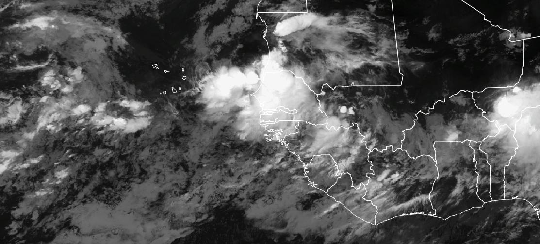
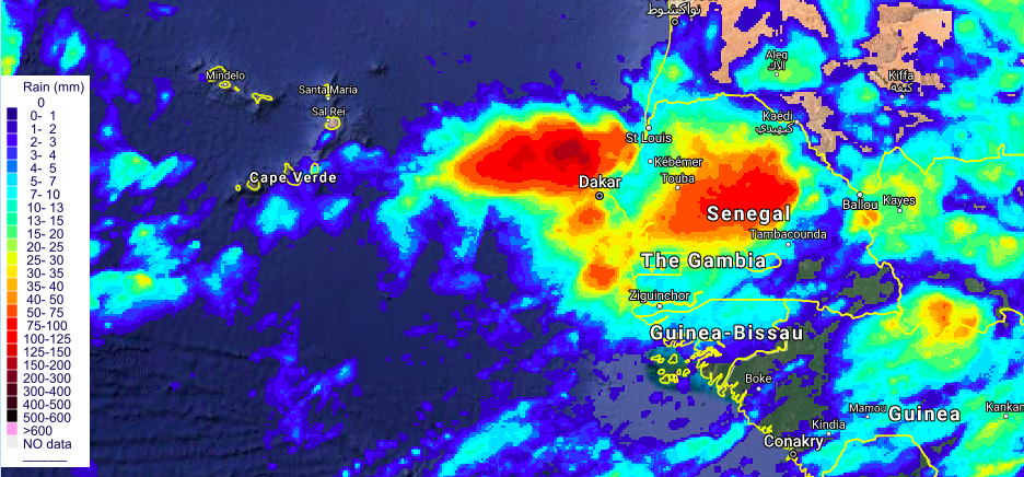
An infrared satellite view from EUMETSAT at 0200 UTC (10 PM) shows deep convection indicating that heavy rain is falling across Senegal, likely creating life-threatening flooding in some regions. Rainfall estimates from UIUC show that a 100 mm or (4 inches of rain) have fallen in some parts of Senegal.
The heavy rain is tied to a tropical disturbance that is expected to develop over the next few days and move across Cabo Verde.
Global Forecast models have had a time determining the strength of a possible disturbance, however they all agree that some type of disturbance is going to pass across Cabo Verde.
I have been using the Weather and Research Forecast model in research mode to determine the potential strength and path of the disturbance. Thus far, the model has been consistently developing a tropical storm that passes across Cabo Verde.
Sep 5 1200 UTC forecasts
Intensity and path of the forecasted storm
In the last model forecast from this afternoon, a tropical depression/storm develops but the path is further south and more likely to impact the island Santiago where the capital is located. The system continues to deepen as travels across Cabo Verde as it moves into Westward. For those of you who remember, Hurricane Florence which struck North Carolina took a similar path (not saying that is is likely as the storm has thousands of miles to travel to reach the US)
The forecast also suggests that much of Cabo Verde will receive winds that could be tropical depression to tropical storm force values especially on September 8. The wind field expands as it moves through Cabo Verde on September 8, with western islands likely to see the strongest winds as the storm deepens.
Heavy rain a major threat to Senegal and Cabo Verde.
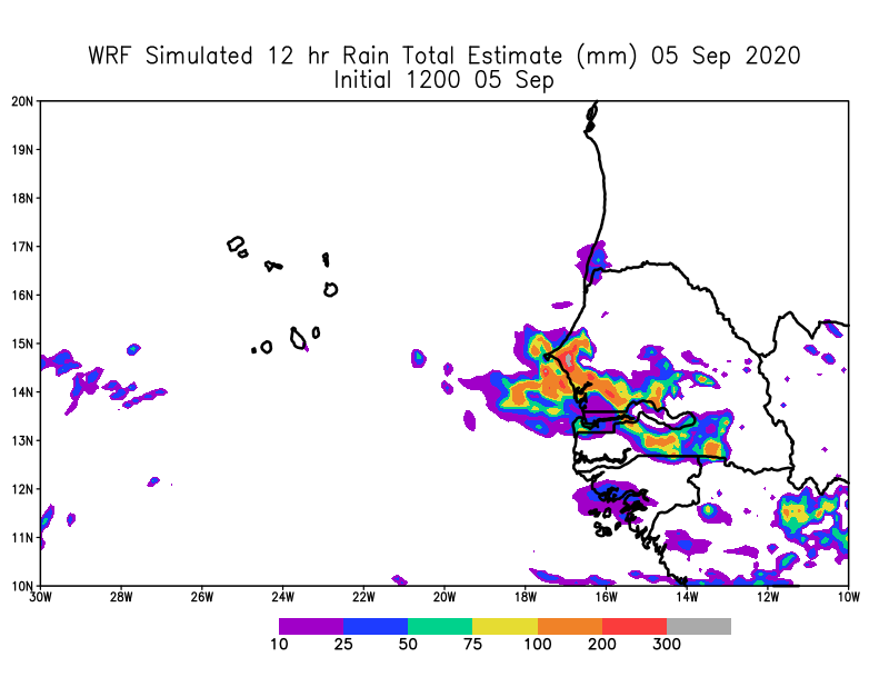
Today’s 1200 UTC forecast shows that a large rain field will develop as the storm moves westward.
The heaviest rainfall would first impact Senegal on 5 and 6 September and then Cabo Verde on during the evening of 7 September. The predicted rain amounts would cause significant and widespread flooding if it occurred. The rainfall amounts were very high near Dakar on Saturday 05 September
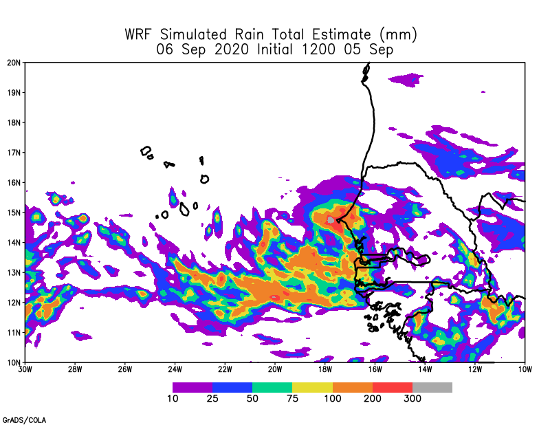
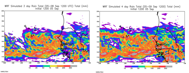
The forecasts suggest that heavy rain will persist in Western Senegal on Sunday September 6 and as the storm moves westward will also produce high rainfall over Cabo Verde. The amounts foreasted in the model are beyond 10 inches for 4 days across Senegal and southern portions of Cabo Verde
Key Take Way Messages
- If you live in Senegal, please protect yourself from heavy flooding and seek shelter if your life is threatened. Please be careful driving and do not drive across flooded roads.
- Heavy rain is possible in Senegal until the storm pulls away from the coast on Sunday.
- While we do not know the degree of the potential storm and its impacts on Cabo Verde, all models indicate that some type of disturbance will make its way across the islands from late Monday through midnight Tuesday and potentially early Wednesday. Better to be prepared.
- A developing system that strengthens will pose some level of threat for coastal zones in Cabo Verde but it is still to early to tell the path of the storm or the strength of the winds which might produce surge and strong beach erosion. Fishermen and women will need to pay close attention to the news and the flag systems at local ports.
- Low lying and flood prone areas should be identified over the next 36 hours in Cabo Verde.
- Stay tuned to your local stations as the forecasts should get better as we get closer to the event.
- If a strong storm does come, make sure that you are prepared to deal with potential power outages.
- Until next time