There is an old statement about love and first sight and love the second time around. But I have learned from a wise one that “sight is not vision” and that sound reaches the heart – whether it is the spoken voice, but especially music. This is probably a recent experience for those of you who saw the movie Sinners and listened to those Blues. But it’s a common experience when mother’s first hears her newborn scream or murmur – seconds or minutes after into this World. But in the world of Jazz, there are people who move you like Miles Davis, Marcus Miller, Joshua Redman, Christian McBride (Philly born), Duke Ellington, Ella Fitzgerald, Nina Simone, and of course the great Billie Holiday (Philly born).
But for me, there are two people, that invoke a spiritual eruption every time that I listen to them: John Coltrane and Alice Coltrane. Now there is another: Lakecia Benjamin. When I first heard her, she came to Philly at the University of Penn and played the music of John Coltrane in 2022. When I heard her blow the alto sax, it was “love at first sound.” I had not heard that sound since listening to John Coltrane CDs which also was “love at first sound.” Giant Steps, A Love Supreme (a song to wake up to every day for understanding your purpose), Living Space, Ballads, Transition, Live at the Village Vanguard (I love the song India), and of course the Coltrane sound on songs like “After the Rain”, “Alabama” “Kind of Blue” and so many others to wake your soul.
Later, listen to Alice Coltrane. Love at first sound strikes again. The songs in Journey in Satchidananda take you on a spiritual journey. When her last song “Isis and Osiris” ends my thoughts are always …No this can’t end. There is another song of Alice Coltrane that I love – “Turiya & Ramakrishna” which has a feeling of soft love throughout it. I was also lucky to hear Ravi Coltrane – the offspring of the giants and see their essence in living flesh, even though I had never seen John and Alice Coltrane perform. While I didn’t get to meet her at Penn, I did read her interview. Sadly, she was at Penn State in February and I never knew.
So back to Lakecia, after the first Penn concert, I purchased Pursuane: The Coltranes
Pursance the Coltranes
This jawn is bad!! Listening to “Spiral” takes me back to John Coltrane’s Giant Steps and she has “Turiya & Ramakrishna” on that CD. My favorite is Central Park West.
Then my sister told me last year, Lakecia, is coming back to Penn in Philly to perform her new album, which I had already purchased been listening to “Phoenix Reimagined) because I heard her one day on Sirius XM – San Francisco Jazz Live and was wowed.
Phoenix Reimagined
I joined my sister, and I could not believe that the auditorium was not full to capacity, but all the betta for us. Then she started with Trane – Bam!! “Love At Second Sound Strikes!!” The level of energy that she brought was out of this world, given that she had just returned from a 40-day tour in Europe. She said that she didn’t know what time it was because of jet lag. Before she played “My favorite things,” she told the front row to buckle in, cause it was going to be a ride. That was an understatement as she went so far, in only the way that John Coltrane could do, using all of her “life force,” to raise us to another level of consciousness. Throughout the show, her personality really spoke to us (she got jokes, yo).
Then, in a dramatic twist, she talked about the title of her CD “Phoenix Reimagined.” The story took us on her journey of driving back from a concert, and then getting in a terrible accident on the road. How a stranger pulled her from the vehicle and helped her to hold on to life while an ambulance, 30 minutes away, came to help her. She talked about waking up on the operating table with the understanding that she had internal bleeding of the brain, and they had to operate to save her life. Later, she was told about the broken bones in her body, including a broken jaw. The doctor told her that he was not sure that she would be able to play the alto sax again. This work received 5 Grammy nominations.
But God and the ancestors told her it’s not time for you to leave or to stop reaching the people’s hearts with your music. Alice and John Coltrane had her back on that highway, and their love kept her on the physical plane.
When she told that story, the love, respect, and gratitude deepened because I realized that we were watching a spiritual being in a physical body, whose purpose was being manifested with every sound and every word. Of course, I enjoyed the music and she played and sang my two favorites – Peace is Possible and Central Park West.
I know that she was exhausted, and still came out to speak to the audience and then sign CDs.
You know, life is so connected, and yet just a stitch in time to make a deep and meaningful connection, even if it is for 2 hours.
Meeting Lakecia..Grateful to be in her space after such a performance.
So while this blog ends, the moments of that evening will linger in my heart for many years to come. Love struck twice with Lakecia and based on her discussion about her next work, it should strike a third time. May God and the ancestors continue to bless Lakecia, aka Phoenix, aka Maat, aka the Beautyful one.
Phoenix (Lakecia) and the Rabbit (me)
Phoenix … you my Boo for life and also the next life.
Happy Mother’s Day to all of the women who manifest and care for the living.
This is the second webinar, designed to provide information and inspiration to those who want to manifest their vision into a startup company. While this might appear to be a Climate, Weather, Water, Enterprise initiative, it is also for anyone with ideas in STEAM, those who author books, develop youth camps or those developing community businesses.
This afternoon, we spoke with the CEOs, Darrell Marshall, PhD, from Total Analysis (https://www.totalanalysisusa.com/learnmore) and Darren Riley of JustAir (https://www.justair.co/about-us), about their companies and the valuable solutions they provide for the Detroit community. They provided a valuable narrative about their companies and also their thought and ideas about the startup space. They are both amazing resources and inspirations to the community.
Dr. Darrell Marshall – Total Analysis
Dr. Darrell D. Marshall is a bioanalytical chemist and the CEO of Total Analysis, a Detroit native building a Detroit biotechnology startup tackling infectious diseases with rapid germ detection technology. As one of only two Black founders in Detroit to receive an SBIR grant, he’s made history. With a B.S. in Chemistry from Wayne State and a Ph.D. from the University of Nebraska-Lincoln, he has over 25 published articles. Under his leadership, Total Analysis is developing Helios 1 to transform disease detection. At the same time, he’s passionate about increasing diversity in STEM and empowering underserved youth in Detroit.
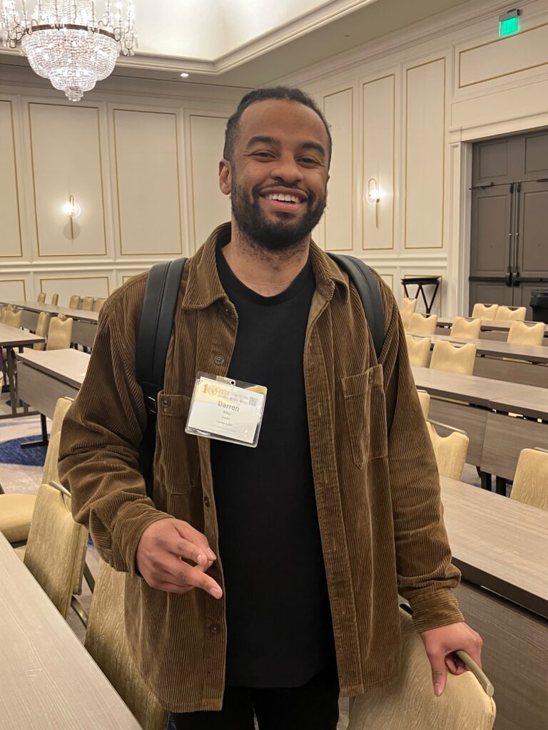
Darren Riley, CEO JustAir
Darren Riley is the Co-founder and CEO of JustAir, a Detroit-based environmental tech company dedicated to protecting the 20,000 breaths we all take every day. Darren was in his mid-twenties when he developed asthma while living in Southwest Detroit, one of the most polluted communities in the country. JustAir began as a project to equip environmental justice leaders with the data and tools needed to understand air quality, educate the public, and organize for change. Today, JustAir has developed outcomes-oriented, scalable technology that addresses major air quality data and management challenges locally and across the country.
With a formal education from Carnegie Mellon University and over a decade of experience as a software engineer, Darren leads a mission-driven team dedicated to ensuring that everyone has access to clean air.
Live Discussion with Darrell and Darren on April 25, 2025.
Since January 20th, the MLK National holiday, we have been forced to address the threats to civil and gender rights, federal jobs, and environmental and climate justice, and we have witnessed the snatching of people who are deported. Federal grants have been threatened, and some agencies, such as NIH and NSF, have been frozen. The Trump administration has effectively closed USAID and plans to do the same to the Department of Education without congressional approval. He has given many federal employees until Thursday, February 6th, to take a shaky buyout. He has threatened to cut the workforce in NOAA and NSF and has been witch-hunting many who appear to be doing work with DEI. Today, he effectively closed the EPA’s Environmental Justice Office. These impacts will manifest as injustices on communities of color; sooner rather than later.
Much of what is occurring has never been seen (except in Octavia Butler – Parable of the Sower), and many cases are pending in court to confront the power grab.
But let’s be clear that this is black history month – “present is past” and “past is present.” We are here because of our ancestors and we limit today’s mistakes through the lens of history.
Thank God and the ancestors that the living legacy of Civil Rights and Black History is alive today through the strong and ethical voice of Attorney Letitia James who has challenged Trump’s and DOGE’s authority more than once and she is on the job protecting all of us.
Two weeks ago, I gave a seminar to the Department of Meteorology on the Legacy of Dr. Warren M Washington. Check out my 30-minute Black History Month contribution to yall about Dr. Washington!!
Today, times are different because we have mobility and probably make more money than our ancestors, but we have more debt, more stress and our sense of community is scattered. If I asked you the question– who is our national black or brown leader– who would you say? I might also ask if we need a leader? Can’t the masses challenge this system? I think it can, but a sense of moral direction from a voice like Malcolm, Martin, Coretta Scott King, or Dr. Beverly Wright can sometimes help keep us aligned or focused on injustice.
Pioneers such as Warren and many others are celebrated because Dr. Carter G. Woodson created Black History Week, which is now Black History Month. It means that no matter the current threats, we lean on the wisdom, courage, and fighting spirit of our wise ancestors who made the way for us. It’s not just the famous people, but it’s your grandparents and great-grandparents who made history by making today possible through creativity, love, courage, fighting, and preserving against violence, hate, lack of opportunity, and even enslavement.
We must find the voice within to carry us–right now, and if that voice is scared…. reach out to an ancestral voice (Malcolm, your fearless grandmother, aunt, uncle, or great-great grandmother/father). Let them guide you in this perceived world of threats. We face intergenerational traumas of the past that live in our bodies, but we also have intergenerational strength from the past.
That is indeed what black history month is. Remember them and find your way back to your authentic power.
Even if we are afraid, we must protect the future, which will face an even more significant threat if we look away now. Please don’t. Fight on today– for the future and honor those who threw up their hands in the past.
In closing, Dr. Warren Washington helped nurture and manifest the beautyful ones in atmospheric sciences/meteorology (the house of life) that protect everyone from floods, heatwaves, hurricanes, wildfires, tornadoes, and all of the disasters now and throughout the Climate Crisis. May he and all of the ancestors help us to protect our communities.
Music by Lakecia Benjamin (in the tradition of John Coltrane)
Happy Black History Month!!! Fight on people– Float like a butterfly, Sting like a bee.
Follow the words of Earth,Wind and Fire + Maysa
“People, be all you can – but now we need faith in our lives to understand”
Keep your head to the sky – the clouds will tell you why!
Over the last year, we have crossed the global mean threshold of 1.5C as a limit set by the Paris Agreement to limit dangerous climate change. The science has been very clear and there is no uncertainty — we must cut greenhouse gas emissions (CO2, Methane, N2O) in order to limit the warming and protect future generations. We have put more than one Trillion tons of CO2 in the atmosphere since the 18th century which can only accumulate in the atmosphere because its lifetime exceeds those of humans (100-300 years).
Presidential candidate Trump does not want to pursue this pathway because his focus is on the present, so we should expect accelerating CO2 emissions from the US. Presidential candidate Harris has been working to reduce CO2 emissions, but there has been a mixed message about the present and future emissions, in part because of political pressure and past practices. If VP Harris wants to address the climate crisis, there will have to be less stress on fossil fuel jobs, such as fracking and on-shore/off-shore gas/oil and put more focus on the creation of jobs from the renewables markets. When people think about oil production, what comes to mind is OPEC and Saudi Arabia. But, the US is now the largest producer of oil making it a significant greenhouse gas contributor.
Increase in Crude Oil output from the US. Source Washington Post.
Furthermore, the number of permits, for drilling has increased under the Biden administration. We know that if Presidential candidate Trump wins, this will only accelerate over time as he wants to get “liquid gold”, which is really “liquid poison” to many communities and future generations, out of the ground.
From the perspective of young people and those not yet born, what is happening seems confusing and has hypocrisy written all over it. The foundation of the issue is the “tyranny of the contemporary”, where we worry about today’s issues only: inflation, interest rates, employment, jobs reports, savings, credit scores, when can I take my next vacation, and how can I live my best life now. We are essentially discounting the lives of those in the global south, poor communities, people of color, the youngest people on the planet today, and those not yet born, including our grandchildren who will face the worst of climate change.
Yet, we have tools informing us (policymakers) on what we need to do in order to limit the climate crisis, to limit tipping points and to protect those who will be here after we are gone. Scholar and scientist Dr. Warren M. Washington, who passed away on October 18, 2024 https://www.fairmountfuneralhome.com/obituaries/Warren-Washington?obId=33523184 was one of those unique individuals who helped to develop the tools that provide us guidance on our actions today. In addition, he helped to foster at least the last two generations of black and brown atmospheric and climate scientists who are working in universities, government, broadcast meteorology, and private industry.
Warren was born in Portland Oregon, and received his PhD from Penn State University (where I currently work) in 1964. He was hired by the National Center for Atmospheric Research (NCAR) in Boulder Colorado, and began to develop NCAR’s first General Circulation Models (GCMs) to simulate the climate of Earth. Within a decade, there were numerous GCMs, including NOAA, NASA and UCLA in the United States and others around the world. This was remarkable, given that the number of black PhD atmospheric scientists in the World could be counted on one hand (Charles Anderson, Godwin Obasi, Warren Washington). Warren went on to be inducted into numerous societies, was the first AMS president, received the National Medal of Science, and advised five US presidents.
National Center for Atmospheric Research (NCAR), Boulder Colorado
Warren was a master craftsman, always working to include the other components of the climate system – the oceans, sea ice, greenhouse gases and making the model more efficient so that it could be run for longer and in more realistic manners. For example, the original models used only fixed sea surface temperatures to represent the world’s oceans. Warren and his team improved the ocean representation to that of a swamp (water source), then mixed layer (water source and heat capacity), and finally a fully dynamical ocean. There was a similar process that he used for sea ice, which was initially only based on thermodynamic and not linked to the ocean circulation. These advances took several decades, and involved team building across sub-disciplines and the advancement of parallel computing.
Warren Washington at NCAR, where data from climate models are stored on tape
Here is an excerpt from Warren’s 1986 book which was read at his funeral.
Excerpts from An Introduction to Three-Dimensional Climate Modeling , Warren Washington & Claire L. Parkinson
“For centuries individuals have dreamed of being able to understand how the climate system works and from that understanding being able to forecast and perhaps even modify the future climate. This distant goal has become more approachable as a result of the invention of the modern electronic computer in the mid-twentieth century. With the computer, it is now possible to solve numerically many of the equations encapsulating the physical laws that govern climate. This provides us with exciting new possibilities … Improved understanding of the climate system could have substantial impact on the economic well-being of the nations of the world. …. Therefore, once numerical models reached the stage where the simulations reproduced major features of the atmosphere, oceans, and sea ice, a logical next step was for researchers to begin using the models to simulate conditions other than those existent at the present time, such as paleoclimates or possible future climates affected by increased anthropogenic greenhouse gas amounts and aerosols. … Numerical simulations should continue to increase our understanding of the Earth’s climate system and provide insight into many factors that may influence climate change. As the models improve, the reliability of their results should increase. The potential benefits for mankind are multifold, as more accurate prediction of future states over both short and long time periods should assist planning decisions in many areas of human activity. One of the real merits of such models is that they allow the quantitative evaluation of possible changes. Mankind will need to make choices about how to respond to climate change, and these choices can be aided by enhanced modeling efforts.”
There are now many clips and recordings of Warren speaking about the state of climate science and climate change that he helped to foster as a scientist, scholar, and voice for black and brown people.
University of Toronto, honorary degree
Why is this a Climate Crisis again?
The primary greenhouse gases are Carbon dioxide (CO2), Methane (CH4) and Nitrous oxide (N2O). Both are increasing at alarming rates. When Warren wrote his book, CO2 concentrations were 348 parts per million by volume (ppmv) and today they are 424 ppmv. CH4 concentrations were 1687 part per billion by volume (ppbv) and today 1927 ppbv.
CO2 and CH4 concentrations. (images from NASA)
Temperatures over the last 12 months are more than 1.5 C above preindustrial values.
Global Temperature anomalies for since 1980 relative to pre-industrial periods
Arctic sea ice which Warren took a real interest in with Claire Parkinson has decreased substantially. It is having a negative effect on the polar ecosystem (life and people).
Changes in Arctic Sea Ice during September 2024. Red line is the 1991-2020 average.
Droughts and Floods
As of the end of October, most of the United States was experiencing some level of drought. The causes remain unclear, but heat domes seem to be related and during this fall, the Jet remains north of its position, with very few weather systems moving from west to east.
US levels of dryness and drought (October 2024).
At the same time, floods have also increased with heavy rain in South and North Carolina this year. In Spain, last week more than 200 people were killed because of floods.
Hurricanes
Two Category 5 storms impacted the United States this year. Hurricane Helene made landfall as a category 5 in Florida, but the greatest devastation and loss of life occurred in Western North Carolina where floods destroyed towns and people are still recovering today.
Destruction of roads in North Carolina (Oct 1) – Washington Post
A few weeks later, Hurricane Milton reached sustained wind speeds of 180 MPH while in the Gulf of Mexico but weakened to a Category 2-3 at landfall, sparing many areas from devastating destruction, but many people were still affected by the storm. More than 100 tornadoes were reported in Florida and linked to Milton.
Hurricane Milton north of the Yuctan (Mexico)
The sum of these events should trigger something to the average person – Change has come.
Warren Washington increased the capacity to fight the Climate Crisis
Warren’s mentoring of students of color over the last few decades has significantly changed the field of atmospheric sciences. Warren was the first scientist of color to be the president of the American Meteorological Society (AMS) and now there have been several, including Dr. Marshall Shepherd.
Warren played an important role in fostering many scientists of color in government, academia, research, and industry. From our perspective, Warren was our North Star, guiding us through unknown terrain towards safety in an uncertain field, where we felt isolated most of the time. Because of his mentoring, we survived and eventually thrived. This list includes Dr. Marshall Shepherd (UGA), Dr. Vernon Morris (ASU), Dr. Arlene Laing (CMO), Dr. John Cortinas (NOAA), Dr. Everette Joseph (Director NCAR), Dr. Belay Demoz (UMBC), Dr. Marilyn Raphael (UCLA), Dr. Lesley-Ann Dupigny-Giroux (State Climatologist of Vermont), Dr. Kevin Petty, myself and many others. Through his mentoring, we were able to mentor a second generation of scientists and many are now moving into successful mid-careers.
If you watch this video, Warren explains that to increase students of color, academic programs must be deliberate and long-lasting to increase representation in the field. At the undergraduate level, Jackson State University has played that role and at the graduate level, Howard University has played the role. At last, years AMS there was a 25th anniversary for the Howard University Program in Atmospheric Sciences program (HUPAS). The outcome of this program was visible, with many of its graduates working in private, government, and academic settings.
Former HUPAS faculty (Greg Jenkins, Everette Joseph, Vernon Morris and Belay Demoz) and the current HUPAS director, Dr. Sonya SmithHUPAS Alumni (Tamara Battle, Drs Segayle Walford and Jamese Sims)HUPAS Alumni (Dr. Michelle Hawkins, Dr. Sium Gremariam, Dr. Jamese Sims, Dr. Yaitza Luna-Cruz, Prof Mayra Oyola-Merced, Dr. Karina Apodaca-Martinez, Dr. Dana Carlis, Tamara Battle)
A pivotal decision and road ahead for Students and Faculty of color
There are two items, that are of concern to the legacy of Dr. Warren Washington
The Supreme Court Ruling of last year. Race is no longer permissible in admissions at US universities. This has the potential to make an already meager number of Black, Hispanic, and Native American students in atmospheric and geosciences decrease further. Admissions officers and faculty can if choose they look away from the inequity that has existed in this country for hundreds of years and instead look at meritocracy. In addition, the anti-DEI movement across the country aims to remove any scholarships that include race, even if the donor wants it to go to students of color. The university will say that such a practice is not compliant with US laws. There is also an effort to remove any effort to hire faculty members of color, with some recent efforts to sue deans who pursue such a path. This flies in the face of what Warren suggested to increase diversity in the field.
The upcoming election. While VP Harris needs to be nudged to mitigate carbon emissions, former president Trump will turn the hands of time back and stop mitigation efforts (he can’t do anything about IRA efforts). He would not do anything to address the need to mitigate greenhouse gas emissions ASAP in order to limit future warming. In addition, he will resist any DEI efforts at the national level and empower states to do more the get rid of DEI efforts in the public and private sectors. Finally, his goal of privatizing government services (such as the National Weather Service) and cutting the government is very dangerous at a time with disasters are increasing in frequency. Such an act would lead to layoffs for many people of color who have dedicated their lives in service to the United States.
Closing remarks
The last five years leading up to Warren’s transition in October have been remarkable. We have honored Warren while he was alive with the Warren Washington Symposium at Penn State, Warren won the Tyler prize in 2019 and there is now a building on campus named after him.
NCAR Director, Dr. Everette Joseph speaks at the Warren Washington SymposiumWarren Washington symposium with former President Eric Barron, the late Fuqing Zhang and me.The weather display reflects Warren’s impact at his symposiumWarren with PSU graduate students and students of color at his symposiumWarren Washington receives the Tyler award with Drs. Everette Joseph, Vernon Morris and Jose Fuentes (2019)Warren and Mary Washington along with Dean Lee Kump and former President Barron for the dedication of the Warren M. Washington Building.
At Warren’s burial site and later in Warren’s office I felt his absence. I wondered if it all comes down to honoring the sacred and silent space of Warren. That sadness lingers within me, but I know that it is not the truth. Warren has left his legacy, with his beautiful children, grandchildren, and great-grandchildren.
Mary and Warren’s two granddaughters.
As for the field, we are sad but thankful for Warren’s mentoring and growing our community. We will follow Warren’s practice and continue to grow, advance knowledge, and protect our communities.
The AMS 100th meeting .
This struggle is not over, and we owe Warren thanks for giving us the tools and will to press forward. We are part of something bigger…
Warren and TaKhari Thompson
We will miss you father, brother, friend, and mentor.
Warren, you are physically gone but will always be our Champion.
Warren thanks for being my research mentor and advisor for the last 35 years. You never led me wrong and were too kind. Your spirit can fly with the ancestors. We will look out for Mary.
For years, scientists have talked about limiting the warming to 1.5 C as a warning for limiting greenhouse gases. Beyond this point, tipping points are approached with potentially devastating damage. We were on track to reach a point in the 2030s, giving us a little time. But guess what: WE PASSED this point in 2023 and 2024. The warmest temperature on the planet was observed less than 2 weeks ago.
EU Copernicus estimates Temperature increases over time relative to historical periods. the highest global mean temperature was recorded in July of 2024
Why is the OK with our politicians? Why is ok with us? Why is it ok that the young ones being born today will have to grapple with a Climate Crisis every year, month, week, and day of their lives as adults?
Climate change is real and has been popping up in all kinds of ways for the last few decades, but especially during the last year. This has been the warmest year on record, globally, nationally, states, and locally. The presidential candidates have spoken about issues of the day – migration, inflation and the economy. But the big dog is lurking right behind us (tens of millions in the US and billions globally) — Climate Change.
Some of you are thinking… the global mean temperatures will revert back to past time, right? Well, I have some bad news for you. It has not reverted back in more than 40 years. Furthermore, a big jump in ocean temperatures has been behind the recent warming and not just El Nino. Most of the oceans around the globe have warmed. Well, the ocean is like a huge bathtub of warm that will not cool down quickly, and because Greenhouse gases (GHGs) are only increasing and trapping infrared radiation, it is acting to keep the ocean from cooling down. There are few scientists in the world who can tell you why the oceans have warmed up over the last 2 years without talking about anthropogenic GHGs.
I know that President Biden is aware of the situation and has implemented policies to address GHG emissions, but along the way has had to compromise. That is nice politically, but the climate system doesn’t care about politics, wars, or anything else except the GHG forcing that humans are imposing on it. It will respond, and when it does there is no comeback, only reaction.
People are worried about the economy, but the many billion-dollar disasters are also taking their toll right here in America. People are worried about migration. Guess what, the climate crisis is already forcing people to migrate all around the world. What’s more, we already know what climate migration looked like in New Orleans after Hurricane Katrina.
The US and Europe want their borders closed. Keep playing with this climate crisis, and you won’t be able to stop anyone because you won’t know which direction they are migrating from. In the US, you gonna have this problem at the state level because people will be migrating within the US. Who knows, maybe Americans will be migrating north across the border into Canada because of the climate crisis.
President Trump has vowed to “drill baby drill” from day one. That’s a bad idea, sir. We have to go the other way and fast so that future generations won’t have to deal with the horrible consequences and also the costs of a much warmer planet. Trump, who is on your science team? They aren’t telling you the truth. You need to fire them.
This upcoming week, Tropical Cyclone Debby will make landfall in Florida. Well that is normal this time of year, but take note of two factors… rapid intensification and the flooding that is expected. On Saturday, at landfall the max winds were about 65-75 MPH and today it expected to be stronger at landfall.
NOAA’s satellite image of TC Debby, August 4th.
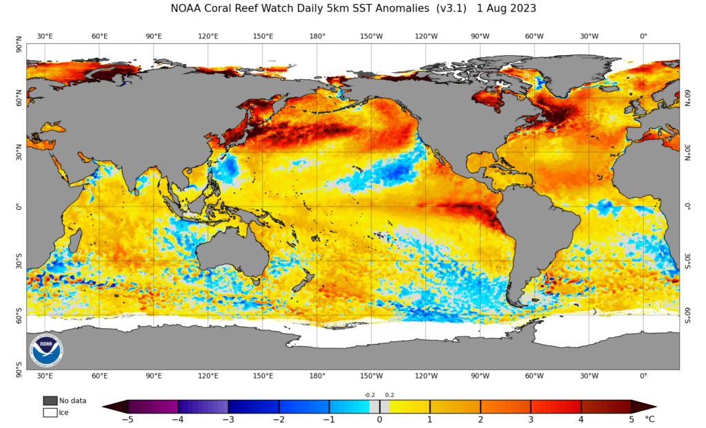
The warming oceans lead to stronger tropical cyclones if conditions such as shear and dry air are not present. The ocean temperature are above normal across most of the Atlantic and Gulf of Mexico.
August 3, 2024 Sea Surface temperature anomalies. Warmer temperatures are yellow, cooler – Blue
The second issue is the potentially catastrophic rainfall that is expected this week. Once the storm makes landfall, the steering currents aloft will collapse, and the storm will rain out in the SE United States. The forecast does not call for a strong enough trough to move Debby northeast until next weekend. So rainfall amounts of more than 1 foot is possible, and flooding is a beast. Where do you evacuate to?
Rainfall forecast August 4 through Friday August 9, 2024
Flooding could be the real story of this tropical cyclone event . In addition to climate change leading to warmer oceans, which can lead to stronger hurricanes, the atmosphere can hold more water vapor, leading to greater rain amounts.
So I ask, why isn’t climate change a leading topic in this presidential race, at the dinner table, and on the minds of Americans? Let’s see how the climate crisis plays over this week, the hurricane season, and the rest of this year. I have a feeling that the climate crisis conversation is one that we can’t ignore forever.
This year we have observed four named storms. Not a whole lot to write home about, but what is noticeable is that the first two came from Africa… kinda Cape Verde tropical storms. However, consider all the abnormal weather we have seen thus far in the US this summer – dry spells, heat waves, floods, and wildfires. Should you worry about this year’s hurricane season? Based on the trends over the last few years, we should be concerned. However, we also are in an El Nino year, which typically means fewer hurricanes because of increased wind shear. Well, what are the reasons for worry:
Above-normal ocean temperatures
Ocean temperatures across the Atlantic, Carribean warmer across the Atlantic from Africa to the Gulf of Mexico.
NOAA Sea Surface Temperature anomalies (degree C) – August 1, 2023.
As ocean temperatures continue to warm through October, developing tropical cyclones will have warmer than normal waters to pass over possibly leading to stronger TCs. This year oceans in the Northern Hemisphere have been outright warm. Across the tropical Atlantic, the lack of Saharan dust events has also contributed to warmer than normal ocean temperatures, because normally dust scatters sunlight and leading to cooler ocean temperatures.
2. The West African Monsoon is active
We are about to enter into the mature phase of the monsoon, which is normally August and September. Consequently, moisture from the Atlantic Ocean and the Gulf of Guinea has been surging to West Africa from the ground through 3000 feet. This will should strengthen westward moving mesoscale convective systems (MCSs), leading to potential flooding in West Africa, and when in phase with emerging African Easterly waves could become tropical depressions soon after leaving the coast of West Africa.
3. African Easterly waves are looking stronger over West Africa
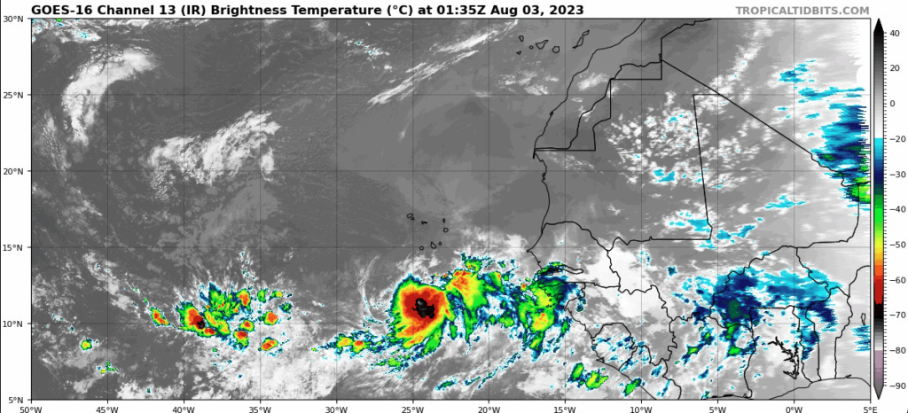
Normally during the second to fourth week of August, AEWs become apparent as they cross Nigeria as well-defined circulations at about 10,000 feet. Over the last few years, there has been a combination of the typical AEWs and the generation/intensification of waves just off the coast, because of fast-moving winds that generate spin (vorticity). Thus far, the second type of wave generation has been occurring with a disturbance currently developing off the coast of West Africa from the satellite vantage point this evening.
Caption: GOES 16 Image showing emerging disturbance off the coast of West Africa (Wednesday 21:35 EDT).
However, at the beginning of this week, models began to forecast well-defined AEWs moving across Chad into Nigeria and moving westward. It could mean that we are ahead of the curve and should expect the stronger wave activity to commence.
Prepare just in case…. OK
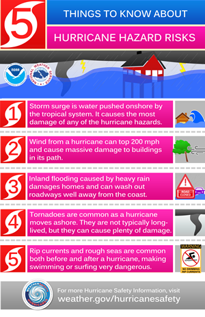
No matter where you are, you should be thinking about the impacts of tropical cyclones during the climate crisis. A hurricane does not need to make landfall in your location to cause major problems. Flooding is a important outcome of decaying tropical cyclones and can be very damaging and also lead to loss of life. Wind damage and storm surge for those living near the coast are primary threats. Below are the five Hurricane hazard risks
Finally, think about putting together a hurricane emergency kit and make sure you consider children, the elderly, and pets. Now is the time!
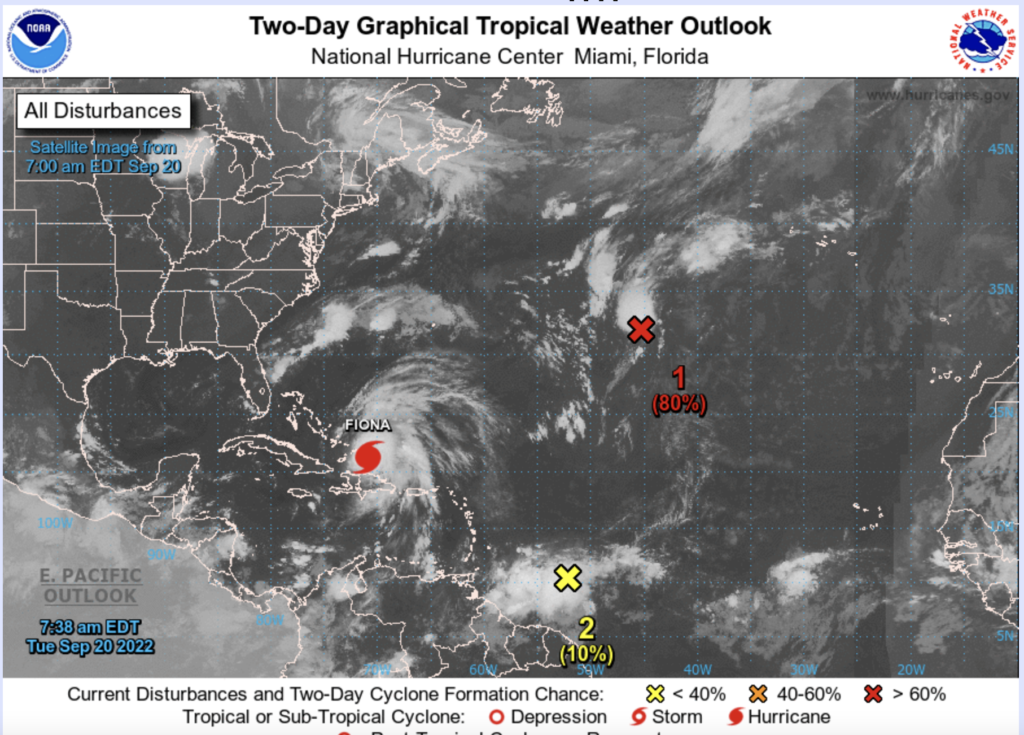
Over the last 10 days, disturbances from West Africa have moved into the Eastern, Central, and Western Atlantic. Unlike the month of August, the waves have not dissipated but continued westward, even in the face of vertical shear. The formation of destructive Hurricane Fiona was such an example. Two additional waves over the Central and Western Atlantic have the chance to become tropical systems over the next 7 days. A third wave situated near 30 W also has a chance to develop. So September might turn out to be quite different from August.
Tuesday Sept 20 NHC 8 AM tropical outlook. 4 potential waves may form tropical cyclones in the coming days
The Source of a Flooding Threat for Senegal
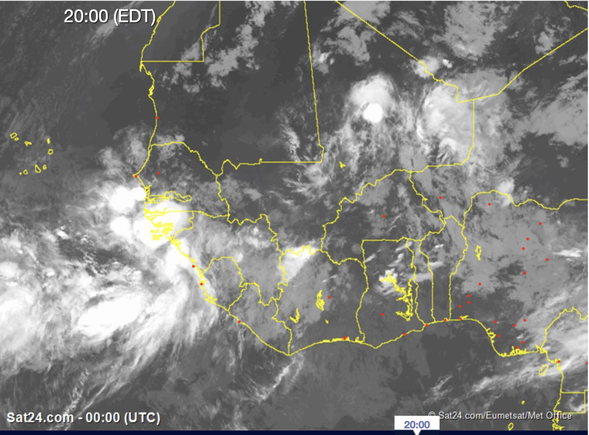
On Monday evening, a new and potentially powerful African Easterly Wave is moving across Burkina Faso and bringing rain over the Central Sahel region. Since last week, global models have identified this feature as a possible tropical cyclone once it exits into the Atlantic. But prior to the AEW leaving West Africa, all indications are that the disturbance will first cross Senegal. The system is expected to bring heavy rain and strong winds to Senegal and the extreme Eastern Atlantic Ocean.
Time of dangerous weather in Senegal
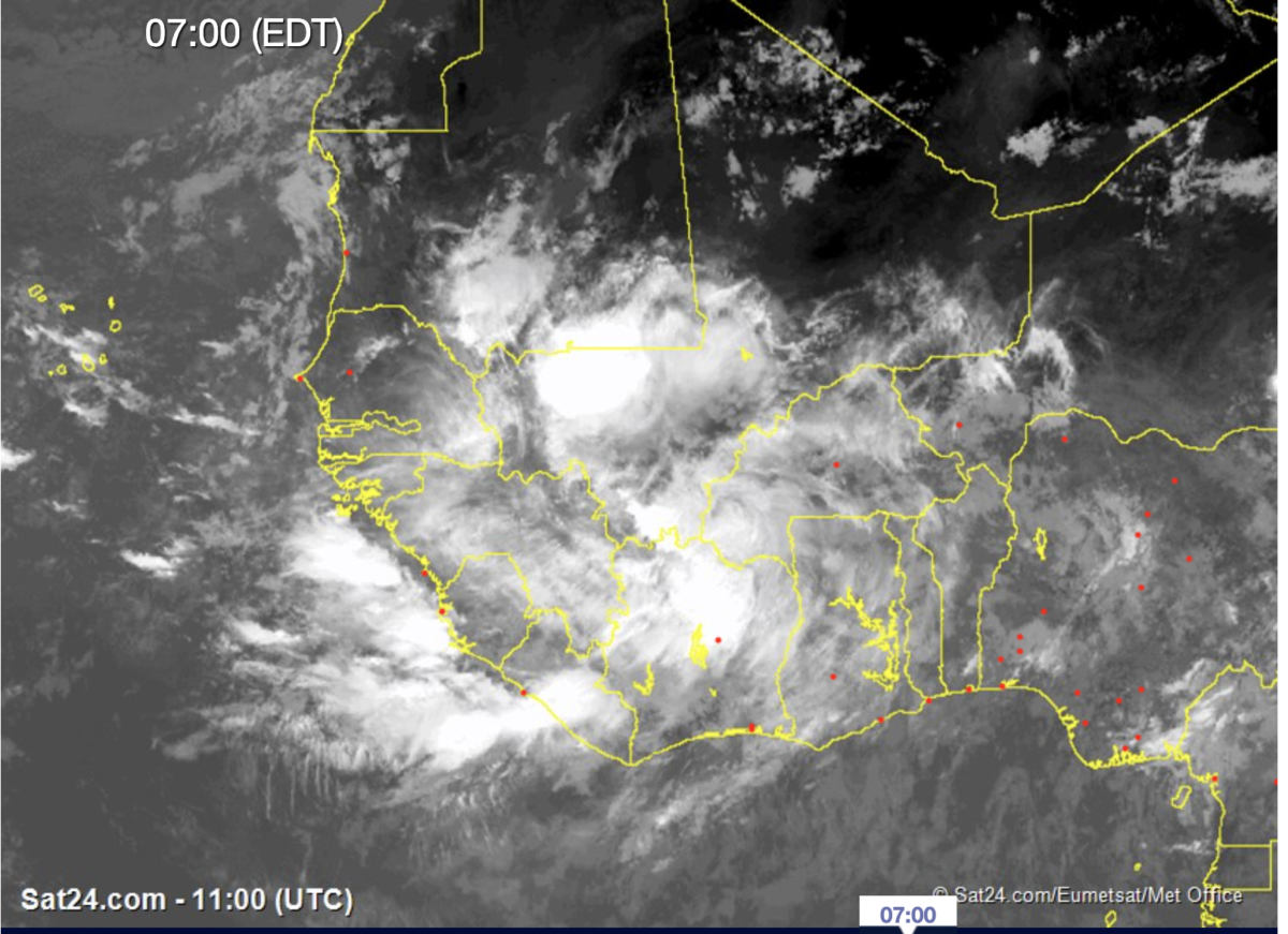
As you may know, tropical rainfall amounts are difficult to predict because of the smaller scale (meso-scale). However, the global models and WRF suggest that heavy rain could begin entering Senegal as early as tomorrow as the wave moves westward. Tomorrow night (Wednesday 21, Sep) through Thursday (22 Sep) look like potentially big impact days with heavy rain moving into Senegal as the system exits the coast.
Monday, Sept 19 WRF simulation of 700 hPa streamlines and Radar Reflectivity.
Any Impacts for Cabo Verde ?
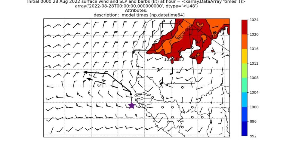
It is still too early to tell, but the global model and WRF suggest that the wave will get pulled north because of a mid-level trough at 500 hPa and not strike the country. Still, this tropical disturbance may have an impact on artisan and commercial fishing along coastal Senegal and Mauritania. There is a possibility that it could become a tropical depression or storm before weakening through shear
WRF September 19 1200 UTC Simulated Sea level pressure and winds
Key Takeaways
Flooding and severe weather possibilities in Senegal will increase starting Wednesday, Sept 21 through Thursday, Sept 22;
Rainfall could be heavy during the night-time hours of Wednesday and Thursday;
A tropical depression is possible off the coast of Senegal/Mauritania;
At present, the event might miss Cabo Verde, but some monitoring and awareness of the event are required through Friday, Sept 23;
Wave activity is still active and likely to impact land areas of West Africa, Cabo Verde, and downstream over the Western Atlantic and the Gulf of Mexico in the coming weeks.
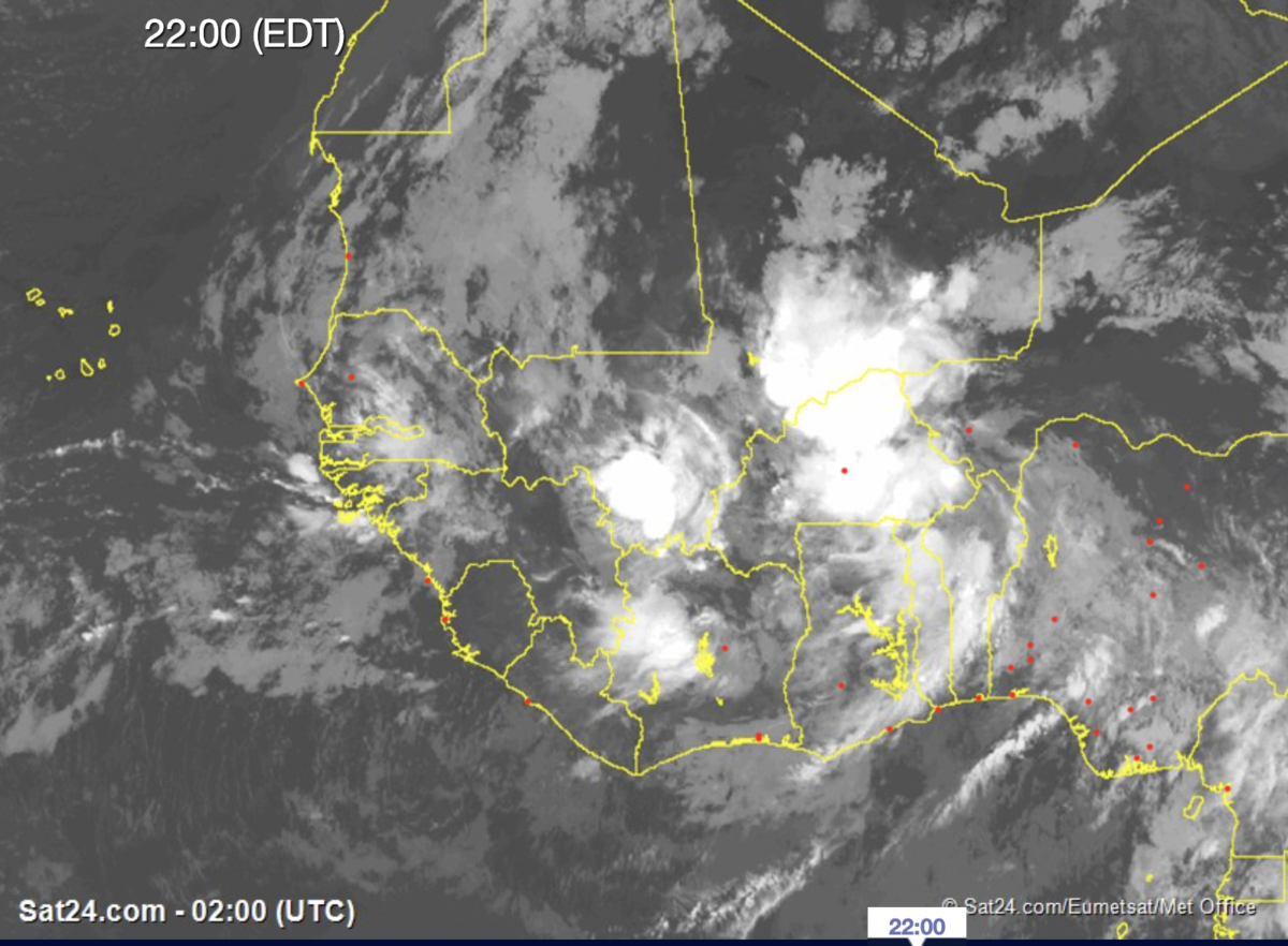
Over the last week, there have been regular African Easterly Waves that have crossed the West African Coastline. These waves have brought some flooding rains to Senegal and plentiful rains to Cabo Verde, where the country has been in a multi-year drought. All of the global models have suggested that a wave would move off the coast yesterday bringing some rain to Cabo Verde.
Infrared Image of Convection with deep convection just south of Praia, Cabo Verde
Forecasting Flooding
Forecasting rain amounts for Cabo Verde is extremely difficult because of the lack of understanding in relationship to the ocean and the limited observations related to the center of the disturbance. In addition, Cabo Verde has high mountains which can cause even deeper thunderstorms, heavy rain and mudslides. The lack of a radar, does not allow us to really know where the heaviest rain is falling across the islands. As we have seen in the US, Pakistan, Senegal and other locations around the world, flooding is increasing, causing fatalities and destruction… with a possible connection to climate change.
The next 36 hours
The wave that emerged from West Africa is expected to slowly move across the country of Cabo Verde bringing heavy rains across the country tomorrow. Where exactly… Most likely the southern Islands tonight and tomorrow.. and extending to the north and west tomorrow into Wednesday. An area of Low pressure in the global and WRF model is expected to traverse the country tomorrow. The low is not very deep so that we do not expect very strong winds. That said, there is still always some uncertainty about potential tropical cyclone development.
ECMWF Monday 1200 UTC forecast of a surface low over Cabo Verde on Tuesday, 1200 UTCWRF Monday 1800 UTC intialized Sea Level Pressure
How much Rain ?
Global models are estimating 1-3 inchest of rain across the country through Wednesday. However, because of the slow movement and the terrain in Cabo Verde there could locally be more… (3+ inches) through the next 36 hours. We just have to see what happens tonight. The WRF model suggest more rain on Tuesday rather than tonight…. But the satellite shows deep convection building tonight.
WRF forecasted 36 hour simulated Radar reflectivity (DBZ) based on Monday 1200 UTC initialization
Because of the uncertainty and the fact that the rain will fall during the night-time hours when people are sleeping tonight, there should be some degree of awareness.
Strong convection continues to build off the coast of Guinea Bissau tonight. Based on WRF model forecast, the conditions should continue worsen leading to potential flooding. After there are two possibilities, the model will carrie the storm towards the northwest or it will go north and then hook west.
Two primary concerns in the next 24 hours
While Tropical cyclone development impact is a concern, there are more immediate concerns:
(1) Inland flooding along Senegal (including Dakar), Gambia, Guinea Bissau, and Guinea from heavy rainfall. Global models and WRF depict heavy rainfall over the next week, with a significant amount of it coming over the next 48 hours followed by a second round later this week..
WRF – Simulated rainfall over the next week
The second threat is dangerous seas and coastal flooding, especially in Senegal and the Gambia. If the storm winds up as forecasted it would produce a very strong southerly fetch causing water to build up against the coastline and causing lots of flooding. Such a manifestation would begin sometime Monday, August 29 and last through Wednesday/Thursday even as the storm pulls away.
WRF simulated sea level pressure and 2 meter winds.
Cabo Verde on Notice
It is still too early to determine a track or any negative impacts on Cabo Verde. The WRF model has continued to develop a tropical storm for the last 3 days at 1200 UTC. Because of the size of the Islands, tropical cyclone track forecasts are too difficult to predict this far out. Let’s hope that it remains a weak system as the global models are suggesting.
I will continue to monitor, forecast, and talk with my colleagues in West Africa and Cabo Verde. If you live in potential impact zones, please stay aware of rapidly changing conditions. The National Hurricane Center has not yet identified this as a threat but may tomorrow.
For the last few days, we have been watching global forecast models suggest that an emerging African Easterly Wave will develop into a tropical disturbance, potentially impacting Cabo Verde. As suggested in the last blog, we are now entered in the period of active TC development.
The Forecast Dilemma linked to poor observations
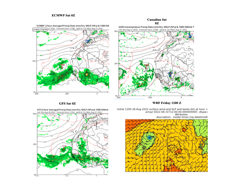
Examining the future forecast of 1200 UTC, August 31st 2022, an area of low pressure is found over Cabo Verde in the ECMWF, Canadian, GFS, and WRF forecasts.
Future model forecast for August 31st at 1200 UTC .
The differences between these model simulations could be life giving rains to farmers or damage to the infrastructure and life-threatening seas for the fishing community. Forecasts all have inherent uncertainty, but Africa stands alone and is driven by human factors alone. The observation network has fallen apart and there are very few upper air observations across the continent. Yes, we have satellites, but I am sure that this approach could not be used in the US or Europe. If you add this to the lack of surface measurements including Radars, the forecast infrastructure resembles the 1930s in the United States, except for the use of Satellites. Is that good enough? NOPE, because we are in a warming climate with more weather extremes and growing coastal populations.
What will happen?The Devil is in the details
All of the models show that the storm over Cabo Verde next week. However, the path to getting there will be the difference maker. The ECMWF forecast the area of low pressure developing from the north (via Mauritania). The GFS and WRF show the development from further south (Guinea/Guinea Bissau) and the Canadian model shows the disturbance crossing Senegal. The ECMWF scenario may not have major implications for flooding and dangerous seas but the other forecasts (Canadian, GFS, WRF) definitely have significant consequences well before any storm arrives to Cabo Verde.
Lessons from the Past (Hurricane Fred)
Back in 2015, I was on the island of Sal when Hurricane Fred passed through Cabo Verde on August 31st. The track that the storm took was similar to the present GFS, WRF model forecast. This disturbance was also forecasted out about 7 days in advance but went through rapid intensification out over the sea. Fishermen were lost at sea off the coast of Guinea Bissau and also Cabo Verde. Damage occurred on numerous islands across Cabo Verde. Along the coast of Senegal, the damage was widespread across many coastal fishing villages and the capital of Dakar. We made recommendations about how to better protect the populations in the manuscript. Nothing has since happened. The value of journal articles.
While we do not know, the exact path of the tropical disturbance, it is prudent to expect potentially dangerous conditions, potentially impacting millions of people from Guinea, north to Senegal and to the west in Cabo Verde. The following hazards are likely
Flooding
All of the models tend to poorly represent rainfall so we must estimate based on what the models project. 100-200 mm of rainfall (5-10 inches) are possible with the passage of the system. The heavy precipitation will commence by tonight through the next 2-3 days in coastal zones–including Dakar.
WRF August 26 7-day rain totals
Dangerous seas
If the disturbance develops off the Guinea coast, dangerous seas should be expected throughout the entire zone. Coastal flooding could threaten fishing communities from Guinea to Dakar, Senegal. The longer the system is off the coast, the more likely it is to generate a southerly fetch to drive coastal flooding in some areas.
Cabo Verde
Based on the current forecast, a tropical depression seems possible but it could be worse. The 1200 WRF forecast suggests a tropical storm moving across the country on 31st. Too early to tell if this scenario plays out but it would likely yield coastal damage from the seas, and strong winds, with potential flooding in some areas.
August 26 1200 UTC WRF forecast of SLP and winds
Pay attention please to your local news
We are in the most dangerous part of the monsoon season in West Africa, with major flooding events over the last 3 years across the region. Senegal and Cabo Verde have both experienced such events. Similar to the US coastal population, you are vulnerable and should have a plan to protect your life, loved ones, and important documents.
The most important thing is to pay attention to the local news over the next few days. Reports of flooding or damage via social media are good given the lack of observations in the region.
Stay Safe, listen to the news, evaluate your state of preparedness, and we will continue to analyze upcoming forecasts and observations.