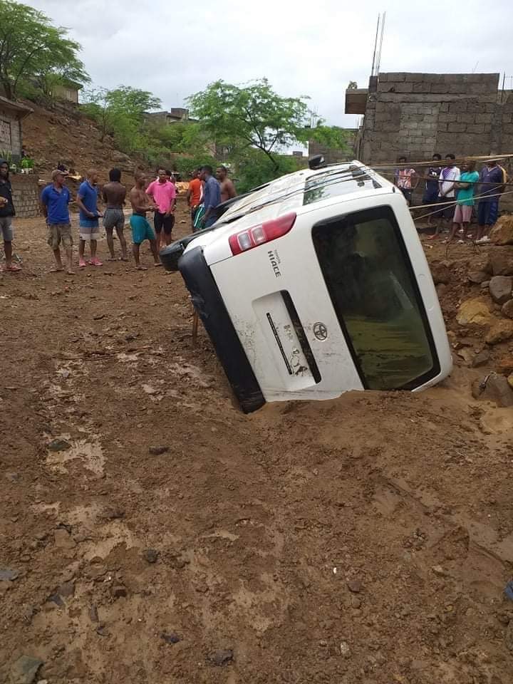
For the second weekend, heavy rainfall is impacting land areas in the Eastern Atlantic. Last week it was Senegal and now it is Cabo Verde. The rain came in late last night as a disturbed area associated with two tropical disturbances developed deep convection and quickly ran over Santiago and its capital Praia. A video from Facebook shows the rushing waters in the capital.

Global models have some issues with this system, because of the interaction with the storm further to the west. This connection means that until these two systems stop interacting then more rain is likely to fall over Cabo Verde for the next 24 hours.

The GFS shows heavy rainfall over the western part of Cabo Verde but there are real uncertainties at present about how much will fall. Rainfall amounts of 2-8 inches are still likely.

The WRF model also shows heavy rainfall over the Western portion of the island of 4-8 (Santo Antao). So when does all of this happen or did it happen already?
Round 2 (Tonight and tomorrow)
Because of the connection between the two tropical systems, Cabo Verde is likely to have more rain tonight and tomorrow, even though the rain has stopped in many areas. Why??
- The main disturbance is still passing across the countrys and this will be a slow process through Monday. Until the disturbance noted at 850 hPa (5000 feet completely leaves the area, rain will be possible.
2. Moisture
The system in the South is drawing up moisture into Cabo Verde and will likely bring more rain beginning later tonight through Monday, with Santo Antao receiving the most rain and for the longest. The humid air at 5000 feet can be visually seen in the WRF forecast. WRF is forecasting rain of varying intensity is forecast to pass across the country tonight and tomorrow morning in parts of the country and through tomorrow night in Sao Vicente and Santo Antao as a result. Based on the latest satellite images maybe in the next few hours rain will return.
3. Low pressure and Winds.
This system has the potential to develop into a tropical cyclone after it passes Cabo Verde in the next few days. It is still possible that the Western parts of the country could see strong winds late Sunday and early Monday. I can’t say with 100 % confidence because there is so much variation in the models and we need to watch the disturbance as it passes Cabo Verde with care and identify any large burst of convection (thunderstorms) which could suggest strengthening.
Key Takeaways
- The situation is fluid and heavy rain with Flash Flooding over Cabo Verde may occur at any point during the next 24 hours over most of the country. Rain should return to areas in the South over the next few hours. Be prepared to move to safety if necessary.
- The Western Islands are expected to receive large amounts of rain through Sunday Night/late Monday. Elevated regions will have enhanced rain. Please prepare. Strong winds from the South may also occur from the South.
- While a tropical depression is not likely until the system passes Cabo Verde late Sunday or Monday, it cannot be ruled out.
- If you live in an area where water can rush against your house, please pay attention because the foundation can be destroyed.
- Don’t drive across moving water. The force of moving water can easily carry your car away along with any persons inside.
- Be SAFE!!
