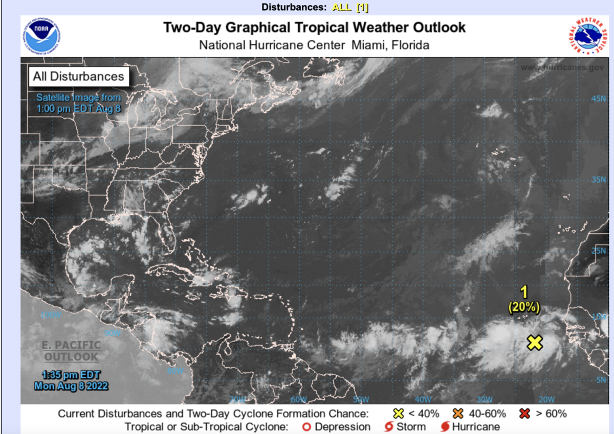
Yesterday (Sunday, Aug 7) was the first time that the National hurricane center has suggested that an African Easterly Wave (AEW) off the coast of West Africa will form. To be sure, it has been a very different Atlantic hurricane and wet season in West Africa.
The Atlantic Hurricane Season
Thus far, three tropical storms have formed in the Atlantic during June and the first three days of July, and since then… zilch. There have been AEWs moving across Africa and transiting into the Eastern Atlantic. So why have there been so few developments across the Central and Western Atlantic? VERTICAL SHEAR. In a typical La Nina Year, the atmosphere promotes less westerly shear and more easterly shear, allowing AEWs to develop over the Atlantic. Did that happen this year? Nope!! There was so much westerly shear aloft that the systems had no chance of developing over the Central Atlantic. The cause for this shear may have been linked to the heat dome over the Great Plains .. just a guess. Anyway, over the last week, the shear over the Central Atlantic has weakened and AEWs have a chance to more development, but a lot of that will depend on the source of the AEWs — West Africa.
The West African Rainy Season
The early seasonal forecast suggested that West Africa would be wetter than normal. Well maybe in some places but not all. Most of the rainfall in West Africa is organized by the African Easterly Jet (AEJ) in the form of Mesoscale Convective systems which are often linked to the AEWs. AEWs look like an inverted letter V, unless they are very strong, then it takes on the form of a closed cyclone. Take a look at the forecasted AEW from August 6 and the simulated reflectivity (rainfall). Rainfall tends to be located around the V-shaped AEWs or where the lines are close together (AEJ), which creates vertical shear and organizes squall lines. Notice that the closed vortex is the one that the hurricane center says has a chance for development. OK enough Meteorology.
What we have seen thus far (June-now), is the AEJ which is located further south at times, or a lack of AEWs. This had led to dry spells and a lack of rain over the last 30 days, especially along the Gulf of Guinea and Mali.
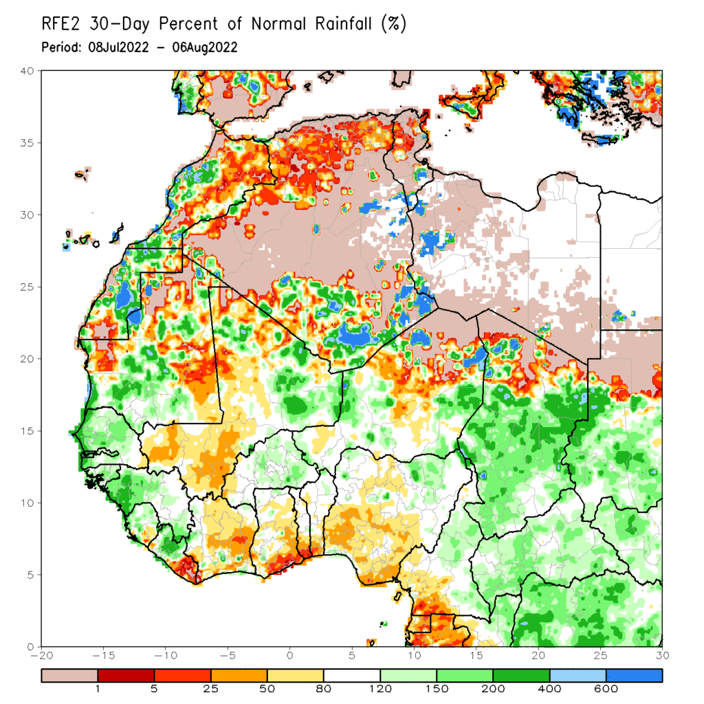
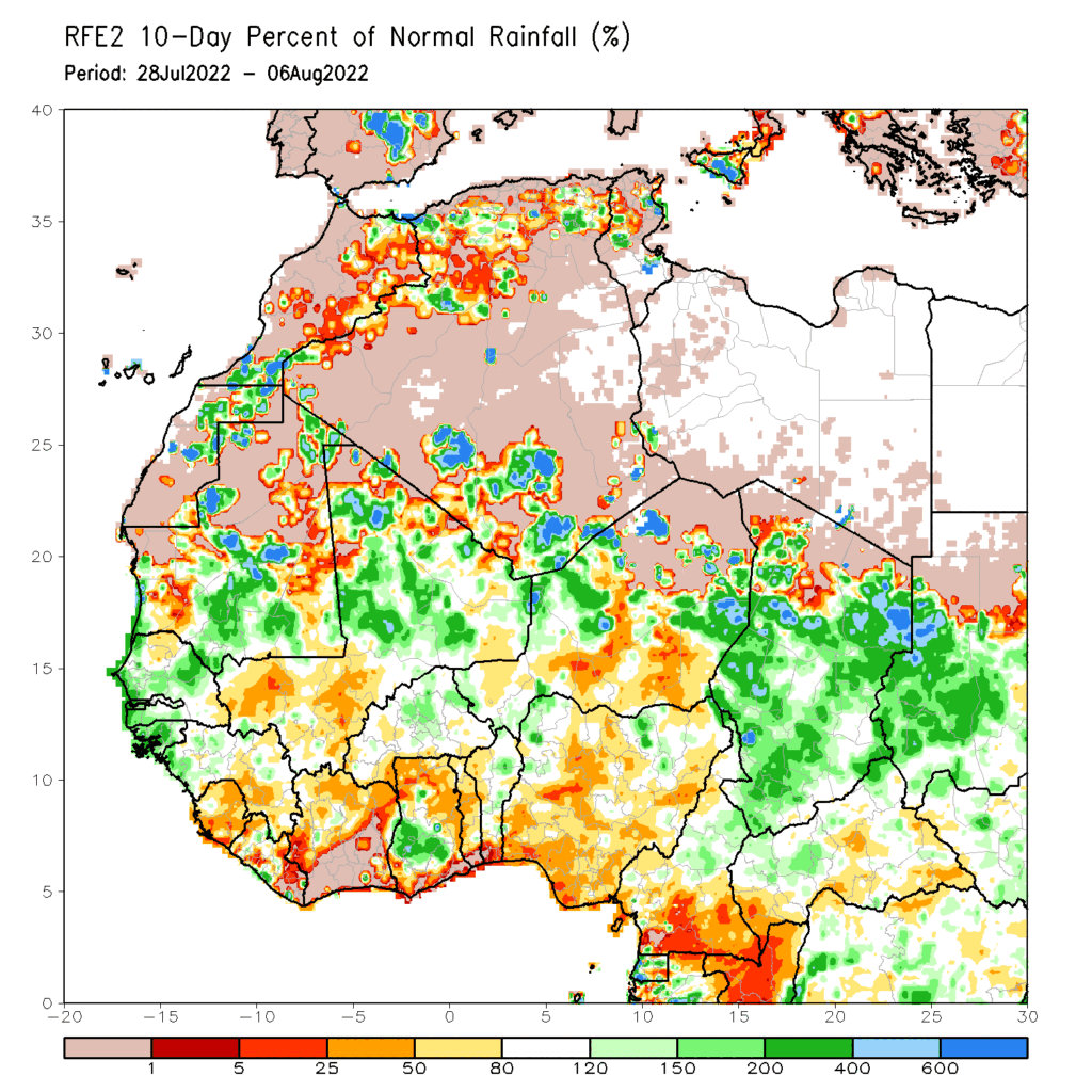
The last 10 days heading into the mature part of the West African Monsoon have been even drier. The exception is Senegal…
Why Senegal Matters for the Atlantic Hurricane Season
Way back in the day, there was a young bright PhD student from Colorado State University, today known as Dr. Chris Landsea of the National Hurricane Center. I was a postdoc and read some of his work, which was being directed by the late Dr. William Gray. This work showed that there was a high correlation between rain amounts in Dakar and hurricane activity. I understand now that more frequent or stronger AEWs when passing Senegal are more likely to develop into tropical disturbances. Over the last two years, we have observed very wet conditions in Senegal, and Atlantic Hurricanes have been very active.
The strange thing is that the flooding has been excessive causing much hardship across Senegal in 2020 and 2021 but not so much elsewhere. For decades there have been discussions about the source of AEWs being in Nigeria or further east in Ethiopia. What 2020 and 2021 brought was the generation of disturbance off the coast of Senegal and moving towards the Central and Western Atlantic.
All things being equal, there should active disturbances emerging from the Eastern Atlantic and heading towards the Americas over the next 2 weeks. If Senegal is wetter than during this period, then watch out – we will be in for a wild ride in September and October. Cabo Verde and all land areas to the west (the Caribbean, Central America, the East Coast and the Gulf of Mexico) should remain vigilant.