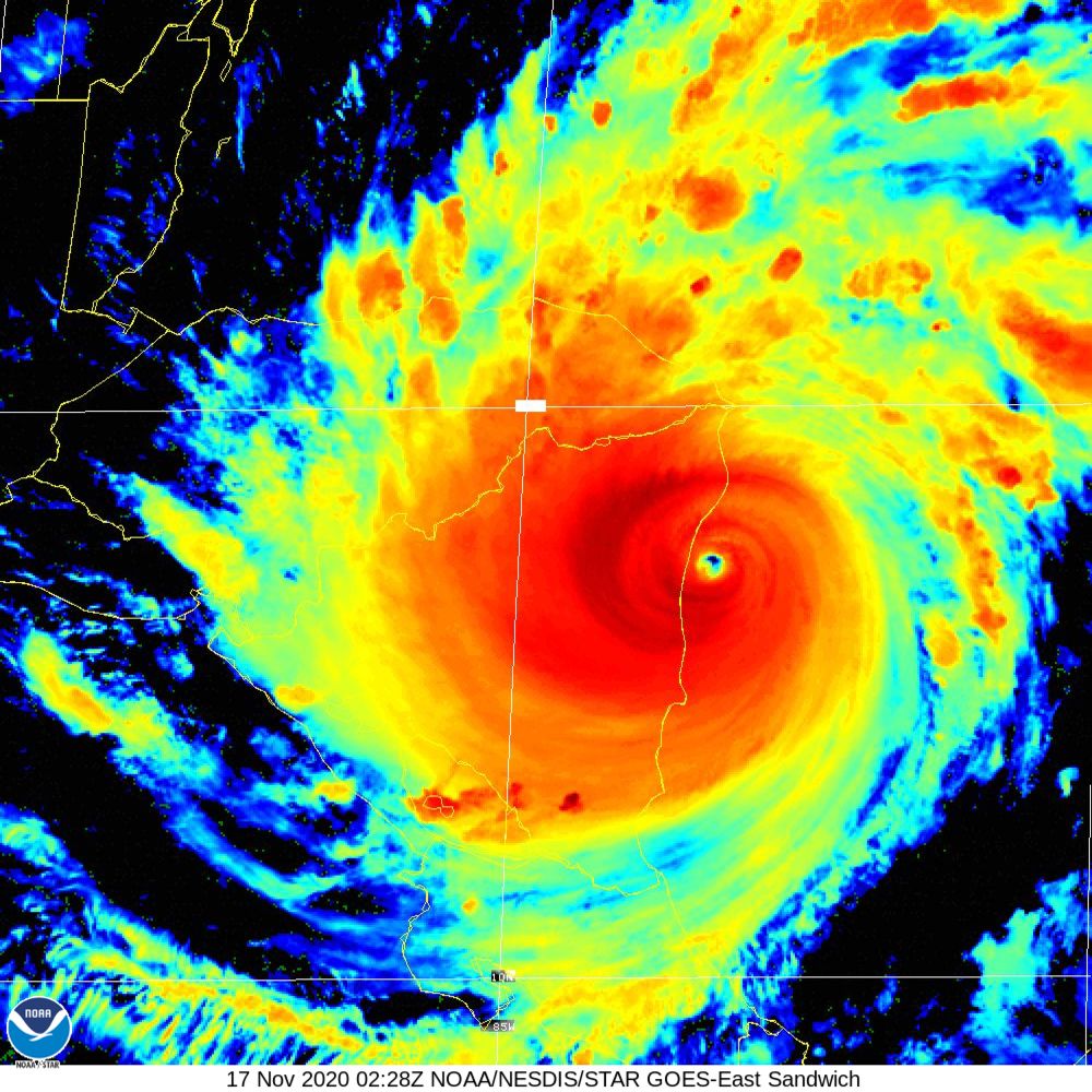
Iota is making landfall this evening as a Cat 5 storm, with an estimated pressure of 918 mb. From a meteorological point of view, it is a beautiful storm with spiral rainbands and a well-defined eye.
Evolution of Hurricane Iota (NOAA)
However, the IR presentation of the storm shows that the power of the storm, with very cold cloud tops, bringing heavy rain into much of Nicaragua at this time, with the eyewall soon to pass over the coastline bring 15-20 foot storm surge and devastating winds.
NOAA/NESDIS/STAR GOES ABI BAND 07 OR_ABI-L1b-RadM2-M6C07_G16_s20203220230497_e20203220230566_c20203220231003.nc3.9 micron movie of IOTA before landfall
We can only keep positive thoughts and hope for the best to the people tonight.
This Monday, we woke up to a vaccine that is more than 94% effective against COVID-19, and President Trump refusal to concede to President-Elect Biden. Yet, Category 5 hurricane Iota should be in the headlines as it barrels towards Nicaragua with a pressure of 918 mb and sustained winds of 160 mph. By itself, it would be expected to cause as much damage as hurricane Mitch, but just two weeks ago, Category 4 hurricane Eta slammed into the same region.
Hurricane ETA at land fall November 3 ,2020
Increasing Intensity at landfall — a sign of the future??
Since Hurricane Harvey, Irma, Michael, Maria, and Dorian and how fast they intensified, I have wondered if this is how the future will play out as anthropogenic greenhouse gases warm the oceans. One is often hesitant to say that storms will rapidly intensify as the Earth continues to warm because the science behind rapid intensification is still not clear. However, this year we have seen a number of hurricanes intensifying before making landfall. But given the potential loss of life and property, the conversation is likely to shift for coastal communities, especially in Louisiana. Yes, it is expensive to evacuate coastlines and people feel annoyed and worried about doing so. But, the time will come when coastal communities will have to ponder the unthinkable- moving away from the coast.
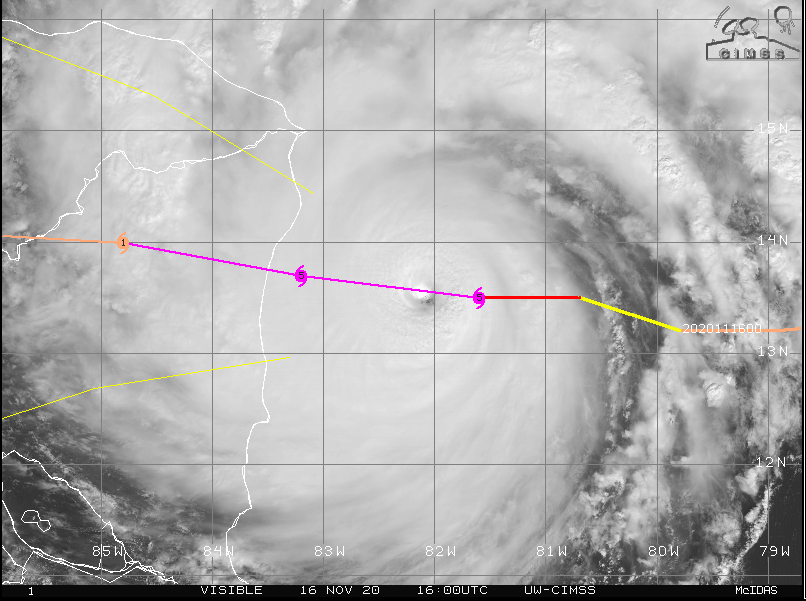
For example, Hurricane Iota has gone from a CAT 1 to CAT 4 in about 48 hours. It was pretty disorganized on November 14 but organized itself yesterday in a low shear and warm water environment
IR movie of Hurricane Iota (November, 14-16) from CIRAVisible 1 km movie of Hurricane Iota (November 14-16) CIRA
I don’t think that it will be some light-switch that will cause this to happen, but probably a series of natural and social factors. The natural factors include coastal flooding, hurricanes, and sea-level rise. The social factors involve safety, rebuilding, and insurance companies that do not want to insure massive losses. In countries that are low-income, the insurance component will matter in low-lying cities but many communities, such as fishing communities may have no choice in the matter. When you have situations, like to ones that happened in Louisiana, Nicaragua, Honduras, and small island states in the Atlantic and around the world, the unthinkable must be pondered by everyone.
Coastal Resilience and Sustaining communities
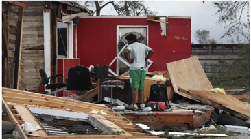
After Iota and Eta, not only should there be thoughts about how the resilience of coastal communities, but also the often forgotten issue of sustainability. When these monster hurricanes make landfall, they destroy so much leaving waste and debris everywhere. Some of this will go back to the ocean, but lots will go to landfills. That poses an environmental justice problem for poor and communities of color which have a long history of fighting landfills, that is located near their communities.
Debris in Louisiana after a landfalling hurricane
Look don’t get me wrong about the presidential race, I care but it’s over. We have to move on. The short term pressure point it COVID-19 and how to protect the population before the vaccine is available. With more than 11 million cases and 250,000 deaths, we have to admit that the situation is dire at present in the US. The reliance on a vaccine instead of behavior and the vaccine is a flaw of a free society where choice seems first. Sometimes, you just have to take a clue from the data, go with it, and accept that freedom and responsibility go together.
Rapid intensification is a major challenge that should have been a mid-21st century issue but looks like we’re early and need to rethink coastal resilience and sustainability.
Stay safe and keep Central America in your thoughts and prayers.
“In West Philadelphia born and raised on the playground…” Every time I see Will Smith or someone asks me where I am from this song rings in my head. Philly is my home, no matter where I travel to or live. I carry the Philly swag, which some people say is roughneck but I am not talking about that stuff. I am talking about the love, grit, brotherhood, and fight that Philly sisters and brothers bring to in so many situations. Whenever I am traveling internationally and someone says that they are from Philly or South Jersey there is immediate brotherhood. I can’t even explain to you how many times this has happened. The strangest time was in the middle of the South Atlantic at Ascension Island during a scientific field campaign where there were only 800 people on the island, and the only way to reach this island was by military airplane or ship. I was asking a guy about the island and asked where he was from? He said Philly – West Oak Lane. I also found out that the commander on the Island was from Camden. This tripped me out because to get to Ascension Island, I took a plane from Philly to Iceland, then England and took a research flight which stopped in the Gambia, flew across the Equator, and landed at Ascension Island.
Ascension Island
Philly in the News
Philly has the notorious reputation for being bad, like throwing snowballs at Santa Claus at the Eagles game, but more recently the city unrest after the killing of George Floyd and the killing of Walter Wallace Jr. by the police leading to outrage and destruction across the city. The 45th president of the United States recently said in his debate with President-Elect Biden ” Bad things happen in Philadelphia.”
But good things also happen in Philadelphia. Let’s just start with the election and Philadelphia helping to decide the election for the nation.
Saturday, November 7 with CNN’s Wolf Blitzer calling the election after votes in Philadelphia
Say what you want but my brothers and sisters went out to vote and it paid off. So a couple of things about the vote. The lines were long on election day (November) with people waiting hours to vote. But, many people sent in mail-in ballots by the bundles, respecting COVID-19 which has been rising at a frantic rate. Probably people who never voted before realized the importance of the moment and the consequence for future generations. Philadelphia is a struggling city with the highest poverty rate in the state, and we still put our fist up when there is injustice, and you gotta fight.
During the 1920s through 1950s Philly was a safe haven for people coming up from the South who needed cover from Jim Crow terrorism. Both of my parents came to Philly and my dad and many of my uncles went to fight in the second world war. These Philly cats when overseas to fight people that never knew but answered to call to serve the nation. My dad served as a squadron leader in the 653 Quartermaster Truck Company in the German Campaign –the dreaded battle of the Bulge (Ardennes GO 40 WD 45) along with the Rhineland and Central Europe campaigns in Germany, received a purple heart, other metals, and a plate in the head after being injured. He was able to buy a house to raise a family in West Philly–known as the black bottom, work as a welder at the Navy Yard, and watch the neighborhood fall apart with massive white flight to the suburbs. The war injury, supporting six children and the stress of the neighborhood caught up to him causing a massive brain hemorrhage and death before me and my twin turned 10. But the Philly fight that he and mom, uncles, aunts, and friends still lives within me.
The new war is around social justice, racism, police brutality, fighting inequity, empowering communities, fighting climate change, helping to nurture and secure the current generations and future ones. Just as in the past and last Saturday, November, 7, the people from Philly are up for the fight. The true source of our fight is based on justice, historical inequity sister and brotherly
Happy Veteran’s Day. Never stop fighting Philly and keep your swag!!
I was shocked to hear the Craig Mclean was fired by NOAA in the newspaper. In his presentation, he speaks boldly about climate change which is something that I have not heard from any government officials over the last few years. He says that scientific integrity is the foundation for the way that we must communicate with the public.
Listen to Craig Mclean’s Presentation (6-minute mark)
Government scientists are supposed to serve the public and not political leaders. We need to find balance or the credibility of science will be completely eroded by the public, whether it is COVID-19, Climate Change, or Hurricane trajectories. The president put in hand-picked climate deniers — not cool–vote.
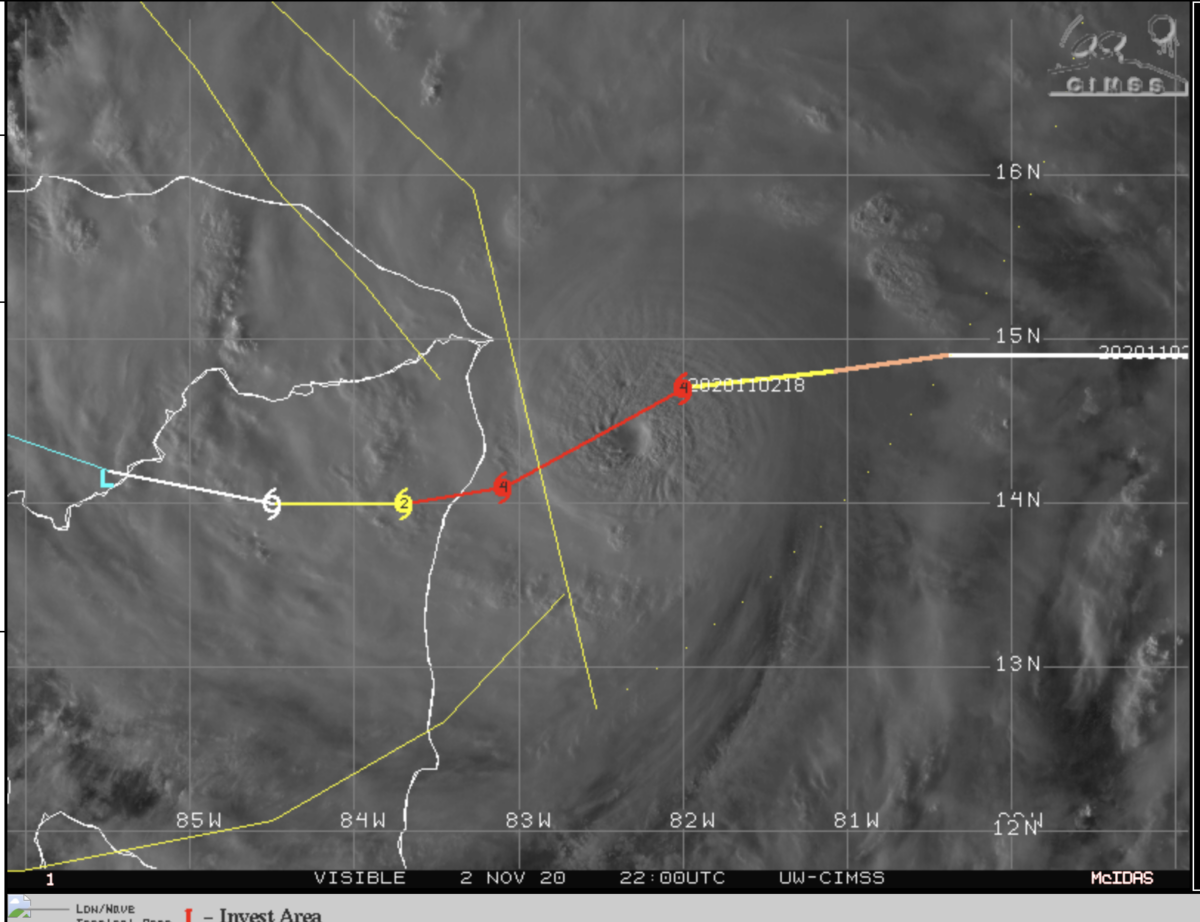
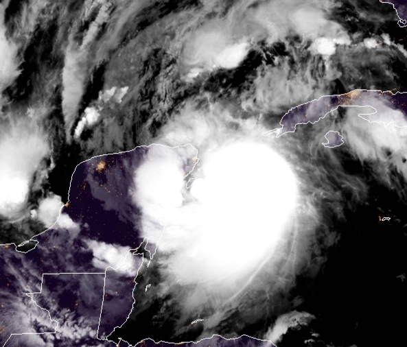
Tonight, we sit at the edge of a tense next few days that will have implications for the short (6 months) and near term future (5-10 years). The US presidential election is divided, polarized, and potentially violent. While we are all concerned about which votes are counted, voter intimidation, and when the final winner will be declared, a major hurricane is bearing down on Nicaragua and Honduras. This hurricane has 150 mph winds (Cat 4) and continues to intensify. This morning it was a 90 MPH storm and may reach Category 5 status before landfall. Before I continue let me take you back in time to the last millennium (1998).
Hurricane Mitch
As a young professor at Penn State, I watched this storm and was awed as it made its way into Honduras and was like OMG.
CIMSS Image of Hurricane Mitch bearing down on Central America (Oct 1998)
Hurricane Mitch killed at least 10,000 people during the few days that is moved across central America. Winds reach an incredible 160 mph and many feet of rain fell as it passed across Central America leading to mudslides. The storm also emerged back into the Atlantic as a tropical depression after massive damage and fatalities. This hurricane called an incomprehensible amount of suffering and grief.
Back to Nov 2020
Not only has this been a record-tying season for the total number of storms, but I have never seen so many storms rapidly intensify as they head into land-masses. Last week it was Zeta slamming into NOLA, and the models all under-predicted the intensity of this event. There are probably areas that still may not have power. While the science of hurricane intensification is still developing, the warm water and ripe conditions (low shear) have made the prediction of tropical cyclones more uncertain. Just one day ago, no model predicted that Eta would become a major category storm and approach Cat 5 status. This has major implications for protecting the population at landfall.
NHC November 2, 7 PM Graphs of Hurricane Eta
Eta is forecasted to make landfall overnight with a devastating punch. with widespread impacts including Jamaica. Check out what the National Hurricane is saying
HAZARDS AFFECTING LAND
----------------------
RAINFALL:  Eta is expected to produce the following rainfall amounts
through Friday evening:

Much of Nicaragua and Honduras: 15 to 25 inches (380 to 635 mm),
isolated amounts of 35 inches (890 mm).

Eastern Guatemala and Belize: 10 to 20 inches (255 to 510 mm),
isolated amounts of 25 inches (635 mm).

Portions of Panama and Costa Rica: 10 to 15 inches (255 to 380 mm),
isolated amounts of 25 inches (635 mm).

Jamaica and southeast Mexico: 5 to 10 inches (125 to 255 mm),
isolated amounts of 15 inches (380 mm) over southern areas.

El Salvador, Southern Haiti, and the Cayman Islands: 3 to 5 inches
(75 to 125 mm), isolated amounts of 10 inches (255 mm)

This rainfall will lead to catastrophic, life-threatening flash flooding and river flooding, along with landslides in areas of higher terrain of Central America.  Flash flooding and river flooding are also possible across Jamaica, southeast Mexico, El Salvador, southern Haiti, and the Cayman Islands.

STORM SURGE:  A dangerous storm surge will raise water levels by as  much as 12 to 18 feet above normal tide levels in areas of onshore  winds along the coast of Nicaragua within the hurricane warning  Near the coast, the surge will be accompanied by large and destructive waves.


Note that the storm may re-emerge in the Caribbean Sea .  So while we will all be engrossed with US politics, please pay attention to the tropics next week.
Nov 3 — Vote
If we don’t mitigate the effects of climate change by cutting greenhouse gases, expect more rapidly intensifying storms. The Trump Platinum plan would be wiped out in one or two Eta storms. His plan is paper thin for black and brown communities that have suffered for decades from pollution emitted by dirty power plants, extraction sites and refineries in coastal zones and all throughout America. He can never produce the manufacturing jobs that we need because he forgets about institutional racism, in addition oil jobs do not employ many people and coal jobs cause black lung and destroy the environment. Jobs from renewable energy provides the best chance for employing young people of color for long periods of time to addressing the climate crisis. Most importantly, his plan does not consider the current impacts that are impacting poor and communities of color from extreme events that are likely caused by anthropogenic climate change. The one item that starts the action to protect the beautyful ones not yet born –the Paris agreement, is never going to be signed if he gets reelected — he said that, not me. I just reiterating the message.
See yall tomorrow. Be safe and remember the ballot is the opposite of the bullet.
One week away from the 2020 US elections with so much tension in the air about the future. COVID-19, anthropogenic Climate change, 27 Named Tropical Storms, strong evidence of Thwaites glacier collapse, plastic pollution, police brutality around the world and need for social justice fills the air like a thick fog. No one knows what the next two weeks will hold and if peace will reign over violence.
In the background, there has been so much discussion about the 17 UN Sustainable goals for 2030.
I love all of these goals, but how do they manifest in the lives of normal people. What can they do? The main problem that I have with the SDGs along with Climate actions to address climate change is that they are top-down. They assume that governments will be the driver in all of these actions and that we should wait for the positive outcomes. The 2030 SDGs point to something that will be achieved within 10 years, which I have very serious doubts about. I remember meeting someone back in 2005 and they told me about the zero poverty goal for 2015. He really believed that it could be achieved and I just chuckled and thought this dude is dreaming. He does not know that the poor are part of a pyramid structure with a few rich at the very top. So while I am 100% behind the SDGs, I don’t know what principles serve as their foundation. Honesty, equity, fairness, balance, distribution of wealth, access, anti-racism, gender balance… and who came up with the foundational principles? Further, who provides the checks and balances?
I believe that the African worldview which is thousands of years old and still practiced today throughout the continent and the diaspora could really provide a functional basis for addressing our major challenges. Let me explain…
Those living are connected to the unborn and the dead (ancestors) where time is not linear but continuous in the forward and backward directions. The knowledge of the past gives us wisdom and is passed down from generation to generation to protect those unborn. Not just the unborn kids that women carry now, but those who will come 100 or 1000 years from now. Many say that one can communicate with ancestors, but at the minimum, they provide protection to the individual and ultimately the community. This connection is a strong guiding principle but there is more to pull from the past…
When people talk about Egypt they think of the Pharaoh and the pyramids. But even those dynasties were built on principles.
Standing in front of the Great Pyramids
But the truth is that the period of the Pharaoh’s didn’t just come from anywhere or an alien society. The principles were very African and built on earlier periods (pre-pharaonic). These principles are literally written on the walls throughout present-day Egypt (Kemet).
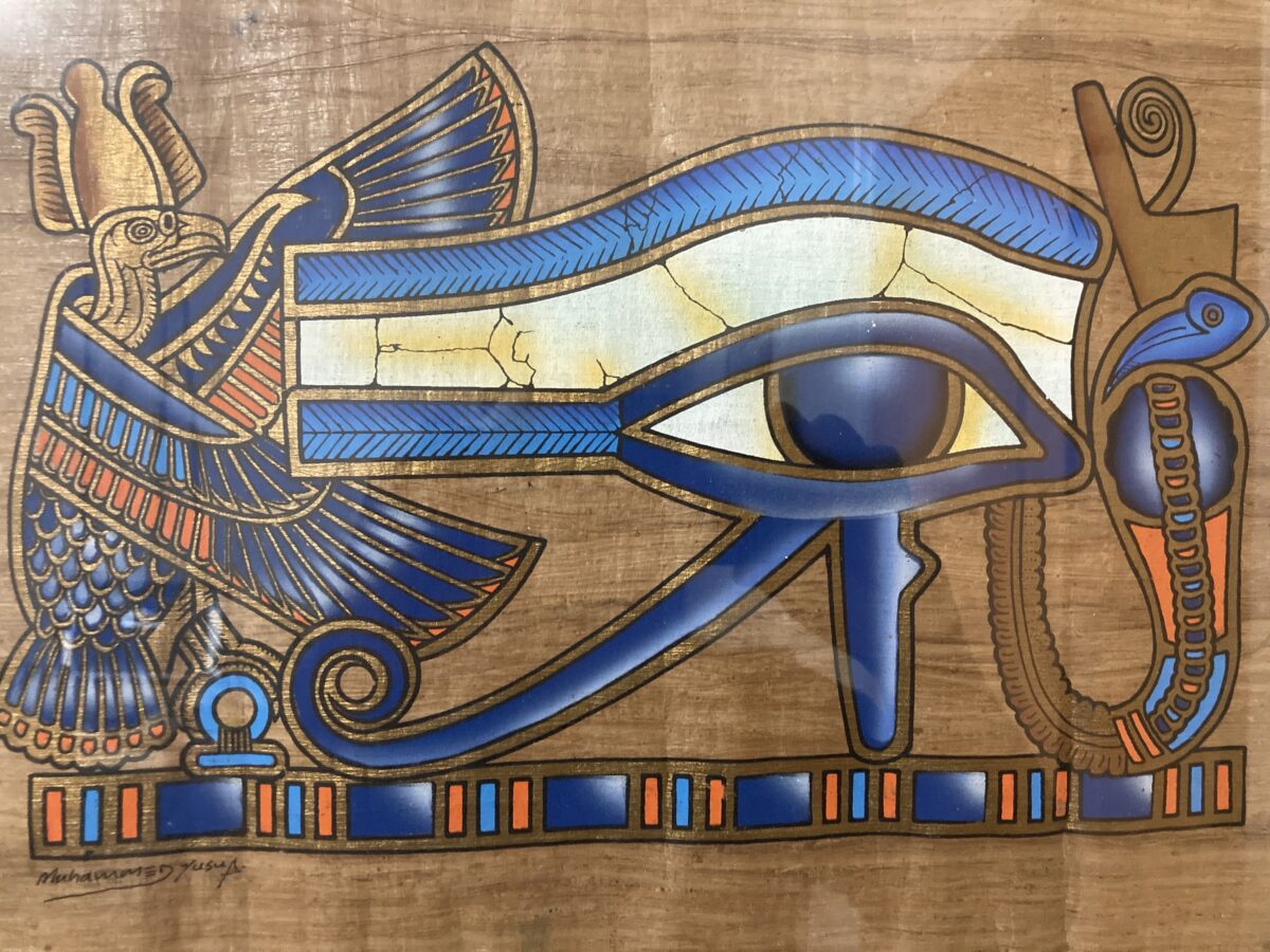
Egyptian writing (Hieroglyphics) on the columns and obelisk in Luxor Asar (Osiris) holding life (Ankh) in both hands with Pharaohs
The pre-pharaonic period provided the blueprint with the Maat sisters (Ast and Nebthet) providing balance, fairness, honesty justice, right thought and action, Jehwty providing measures to build, protect advance the mind, community and society, and Asar providing the voice to spread the blueprint to individuals and societies to improve their situation — he was a sharer of knowledge and not a keeper of knowledge like many of the institutions of higher learning that exist today.
Using principles such as those from Pre-Pharaonic Egypt and the African Worldview how can any individual, family, community come to grips with the multitude of challenges facing the globe? First, the principles of Maat and Jehwty gives each of us guidance about how to deal with challenge. For example, is my solution balanced and fair?, does it take into account the widsom of the ancestors?, does it protect future generations?
Lets take a stab at some contemporary problems
COVID-19
This is a disease that has killed more than 1 million people worldwide and more than 230,000 in the United States alone in the last 10 months. While we are all thinking about vaccines, social distancing, and masks as solutions, what would the African Worldview suggest? First, it would ask about the unborn, living, and ancestors. The elderly who are inline to become ancestors would be protected the most because their knowledge and wisdom must be passed down to the living and the unborn. When the grandparent dies before the proper time, knowledge, experiences, stories, and wisdom are lost and not sharable with the unborn.
So the burden falls on the living who must ask: am I using a fair and balanced approach along with right thought and action to protect the elders and the unborn? It’s not about your freedom but your responsibility.
Having widespread tests available to monitor the disease is the principle of Jewhty and spreading the word about the dangers is the principle of Asar. Such principles would likely lead to a reduction in the disease prior to any vaccine. We have the ancestors who survived the 1918 pandemic and wrote about their experiences, how do they inform us? It’s not about Dr. Fauci, Trump, Biden or the government but each individual.
Climate Change and Extreme Weather
The need to provide energy for society is natural, but when that need endangers the living through extraction, toxic fumes, oil spills and warming which threatens the oceans, may collapse the ice sheets, and is fueling weather extremes the principles driving the action are wrong. What about the African Worldview.
First, any activities that threaten the living would need to be addressed. This is the principle of Maat and considers the fairness and justice of such activity. Once it was clear from the observations (Jehwty) that dangerous outcomes were possible and this was discussed locally or globally (Asar), then the right thoughts and actions would be required. Not for the sake of profit but for the protection of the living and unborn, period!
The technology to move away from the negative impacts of fossil fuel already exists but the action of a typical politician does not consider justice. They see power, staying in office, and control of resources and people. This is a losing proposition. So what about the individual? Each of us must consider right action and thought, because we know that change is occurring now, with floods, fires, hurricanes, and warming.
We are past the point of asking if scientists are confident, now we must protect the present and future with our own right actions. At a minimum, vote for a president who protects the unborn by acting to mitigate greenhouse gases and preparing society to adapt. Conserve energy by driving less, winterizing your house, buying fuel-efficient cars, hybrids, or electric vehicles. Put pressure on your representatives, jobs, and cities to see carbon neutral policies. Most of all, consume less because that is the driver of emissions. When the time comes, we will have to accept adaptation — some areas will not be liveable from Climate Change. Such a sad thought but we will have to explain it to the unborn.
Sustainability
This is the core principle around the African Worldview. In this worldview, an individual or society cannot deplete resources, leaving anything for the unborn. I think about the fact that elephants were abundant in Senegal throughout time but taken for ivory and within two hundred years depleted by Europeans who also took people as slaves in collaboration with the various kingdoms in Senegal. There is a balance between nature and society with the ancestors providing the best practices on addressing scarcity and wealth. They presented no deadline like the SDGs for 2030, it was a way of life. Profit does not take precedence over the people or the environment. Sadly, the development of western civilization came at the expense of Africa and other indigenous societies in the Americas and Australia. The African worldview was seen as less because it never sought outright profit without considering the consequences.
However, I might say that hierarchical systems in Africa (kings and queens, militaries, governments) did not and do not share the core principles of the African worldview (slavery, caste, and class systems are wrong). So the principles of Maat, Jewhty, and Asar could not be implemented in such a system and the foundation was already in place for TranSaharan and TransAtlantic Slavery with Europeans arrived. Today, extraction, loss of biodiversity, and injustice can be found across the continent and the diaspora based on profit and greed.
But this will not last forever. Either individuals and societies will find justice, balance, honesty, right thought and action or we and the unborn will continue to suffer the consequences of wrong action.
Still, I believe that even in our faulty thinking there is hope, as titled by author Ayi Kwei Armah The Beautyful Ones Are Not Yet Born — but they are coming.
To learn more about the pre pharaonic period and the African worldview consider reading Ayi Kwei Armah book wat not shemsw– the way of the companions and other books which can be purchased from Per Ankh publishing (bbkwan.com).
Stay cool, and calm (right thought and action) everyone over the next week and vote. Be nonviolent and seek a state of peacefulness.
This morning I am moderating a session on extreme events, which can be watched live at 10:30 EDT (Wednesday, October 7 – https://allatlanticsummit2020.org/live/extreme-weather) in the All-Atlantic Summit (https://allatlanticsummit2020.org/) from Portugal, from Cascais near Lisbon, which are both beautiful cities but quite vulnerable to coastal storms. My center AESEDA (aeseda.psu.edu) is co-hosting this virtual meeting which was to be held in Philadelphia. This summit is focused on the Blue-Economy across the Atlantic and all presentations are available live stream or you can watch them later.
Looking at the Port in Lisbon, Portugal
It is the romantic allure of the sea along with commerce that has drawn billions of people worldwide to live in large coastal cities. And while you get a fantastic feeling standing near the sea, you should also know it can be a source of natural hazards and will be the source of a persistent danger because of sea-level rise, now and for future generations.
The Atlantic Ocean when viewed from from Portugal
As of today, we have experienced 26 tropical disturbances, with two systems (Gamma and Delta) forming over the last 10 days. We still have 50 days left in the Atlantic Hurricane season and this will most likely be a record season for Tropical cyclones (27 in 2005). As Major Hurricane Delta impacts the Yucatan later today and the Gulf Coast on Friday, I wonder if all of this talk about coastal resilience is for nothing?
National Hurricane 1 AM Central Daylight Advisor, Wednesday October 7, 2020
Should we retreat from the coasts or build stronger structures?
Most of us would go with the second answer because as humans we feel that we can always do better. However, the billions of dollars lost over the last 20 years suggest that this might not be the best strategy. The other often overlooked issue is one of equity and justice. There are large disparities in wealth along class, gender, ethnic and racial boundaries. Everyone, cannot afford to rebuild nor can they afford to lose all that they have worked for. Finally, in some locations, such as small island states (Caribbean, Bermuda, Azores, Cabo Verde), the vulnerability cannot be reduced for major hurricanes as we saw with Hurricanes Maria, Irma and Dorian.
A participant at the conference said that retreat is not the worse thing and I tend to agree with him. He was referring to flooding but there are some locations that will flood over and over, no matter what you do. You cannot build resilience in these areas and to move people from the threat seems like the most responsible action.
It won’t get any easier or better for future generations living in coastal zones
Warming oceans, increasing coastal populations, rising sea levels all point to disasters of epic proportions during the coming decades and centuries. Let’s go through each of these carefully.
Warming Oceans. As the oceans warm, it evaporates more putting more water into the atmosphere. A warmer atmosphere from climate change can also hold more water vapor. This is most likely to lead to more flooding when tropical cyclones form. Warmer oceans also drive stronger hurricanes because it is the conversion of water vapor to liquid rain or frozen ice (very high up), that provides the release of latent heat which drives stronger thunderstorms and updrafts in tropical cyclones. This year we have seen marine heatwaves along the East Coasts of the US and tropical systems were stronger when passing through these areas. By mid-century, all of the oceans will be much warmer than the preindustrial period. Not a good look at all coming.
Sea Level Rise. This poses the greatest long-term threat in my opinion. If you are free today, Watch today’s (Wednesday) on sea-level rise (https://allatlanticsummit2020.org/live/sea-level-rise) at 12 noon EDT (1600 UTC). Dr. Richard Alley, one of the top glacier scientists in the world will show that the large ice sheets are in a state of decay and could pose a serious threat for the next few hundred years potentially in the next few decades. The threats have shifted from thermal expansion from a warmer ocean to the melting of Greenland and now to the potential collapse of Thwaites glacier which raises sea level by 10 feet. Even if this does not happen now, it will happen this decade leaving many coastal communities unlivable.
More intense Natural Hazardsand damage
Natural hazards such as hurricanes or floods have always posed a threat to coastal populations, but there is a multiplier effect in play today. This multiplier effect will increase in the future with warmer oceans, higher atmospheric water vapor amounts and higher sea levels. The current hurricane season suggests that people should begin to think about their living environment relative to natural hazards, if not for themselves for their children.
Do we have a choice but to live with what is happening?
We have a choice, but time is running out. We must hold each other accountable for limiting greenhouse gas concentrations. How can we do that?
Reduce your consumption. The more you consume the more energy that is required to make those goods and services and hence more greenhouse gas emissions.
Try to be an energy-efficient person.... Turn your lights off, weatherize your house, get solar panels..make electric cars affordable, and drive them…
Educate each other about the threats that we are facing. We should have answers when people ask us about the destruction caused by flooding or hurricanes.
Hold your leaders accountable. President Trump has put the United States in an isolated position by withdrawing from the Paris Climate Agreement. The US must re-enter this agreement if we have any chance of working globally to reduce the biggest threat of the 21st century across the globe.
Make a choice about coastal resilience
We can’t have the cake and eat it too in the case of Coastal Resilience. The evidence points to a continued loss of coastal resilience at present and while we can’t stop it, we can slow it down. The only way to do that is to MITIGATE greenhouse gases. This is a collective action of the people. Support politicians who support the future of your children and grandchildren. It’s not just about us !!
Save the date Oct, 7 2055.. for a beautiful morning and breakfast with your grandchildren.
Wednesday morning, October 7, 2020 at the Cascais, Portugal
Wave over Burkina Faso this afternoon moving west on October 1
I have been away for the last few weeks, but always watching the waves. The wet season has come to an end in the Sahel (south of the Sahara desert. However, a late-season wave may cause problems along coastal Africa from Sierra Leone through Senegal this weekend and Monday. It is unclear if the disturbance will have any impact on Cabo Verde. The models have not handled this situation very well and so it needs watching over the days ahead.
The disturbance is best captured at 10000 feet which show the system moving westward in yesterday’s forecast and then moving northward along the coast this weekend.
700 hPa Vorticity showing system moving North
The system will probably produce rain along the west coast of Africa but rainfall is forecasted poorly in general, with the most likely rain coming this weekend through Monday.
Simulated reflected based on 30 September 2020 1200 UTC forecast.
While there is dry air occasionally coming into the zone at 5000 feet, it does not appear that it will play a big role in the weakening system this weekend. The moisture provides a pouch for the system to develop. This is another reason to keep a watchful eye.
850 hPa Relative humidity and streamlines.
The African Easterly Jet (AEJ) at 10000 feet has gone south which means the zone to watch for disturbances is now over the Gulf of Guinea. These storms are less likely to be impacted by Saharan dust over the next few weeks, but Saharan Air will eventually become more important.
African Easterly Jet (AEJ) Forecast at 700 hPa
The Western Atlantic and Caribbean Sea
The weakened waves that come from Africa can still form tropical disturbances in the Western Atlantic and the Caribbean Sea, but it becomes complicated in October. Upper-level shear, troughs, and even mid-latitude fronts can complicate the situation relative to the summer. The National Hurricane Center is watching two potential disturbances, with models producing different solutions at this point.
NHC tropical outlook page on Thursday Oct 1, 2020
If you live along the Gulf coast, please continue to listen to your local news as October storms can move quicker than summer storms because of mid-latitude troughs. Whether you are live near the Gulf of Mexico or along the west coast of Africa, please stay vigilant over the next week!!
After two weekends of flooding in Senegal and Cabo Verde, this has been a quiet week. The African Easterly Wave (AEW) that emerged from the coast is moving steadily towards the west across the Eastern Atlantic and may become a tropical cyclone in the days ahead. The lack of waves this week gives much of West Africa and Cabo Verde a chance to dry out. The seven-day forecast that was run on Sunday provides a verification that there are no large-scale currently crossing the continent during mid-week based on 700 hPa vorticity.
7-day 700 hPa Vorticity based on 13 September 1200 2020
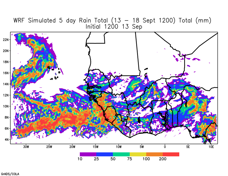
Consequently, forecasted rainfall across the Sahel is expected to be less during the week and also shifted to the south.
5 day total rainfall forecast for 13-18 September 2020
Inland Disturbance will move to the coast by week’s End.
The WRF forecast shows that a disturbance will reach the coast next Sunday. Further, the WRF forecast at 850 hPa indicates that the disturbance has a northern and southern component. In these situations, the AEW is in phase and could emerge as two different disturbances or merge into one storm. One worrying trend is that global models are suggesting that the main disturbance over Mauritania will have a more southerly latitude potentially impacting countries to the south.
850 hPa Vorticity showing a disturbance over Mauritania at the end of the forecast.
We will have to watch the forecast more carefully starting tomorrow. Meanwhile, keep those along the Gulf Coast in positive energy and thoughts as they prepare for Hurricane Sally and Bermuda after they experienced Hurricane Paulette.
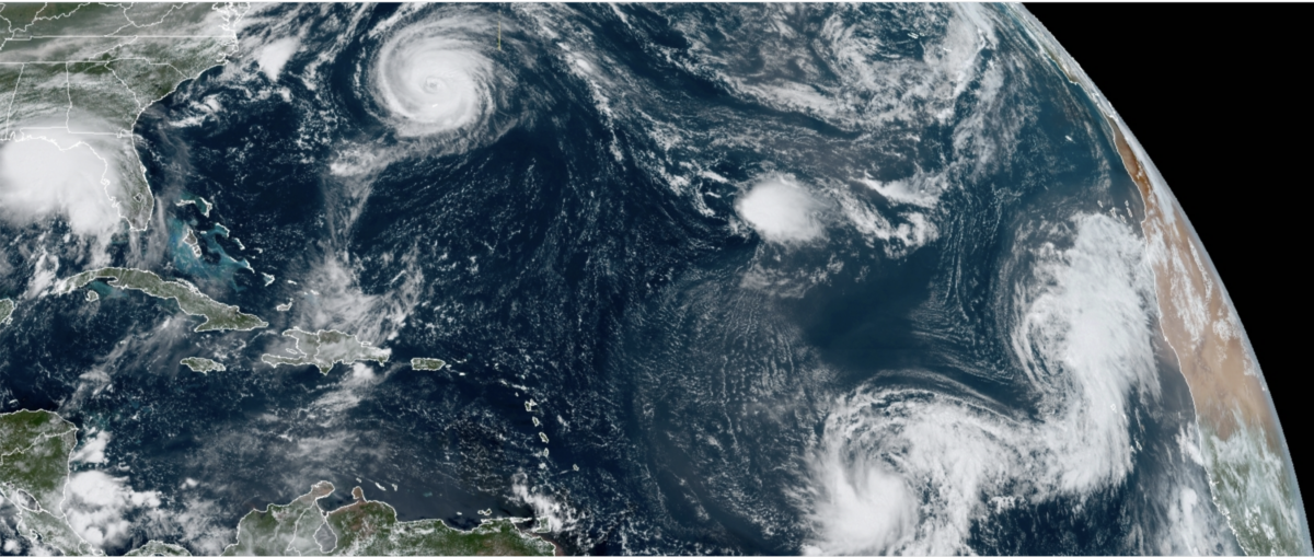
Today, there were five tropical systems across the Atlantic, with a 6th emerging off the coast of Africa.
National Hurricane Center tropical outlook as of 11 AM, Monday September 14.
I thought 2005 was bad, but I have never witnessed anything like this in all of the years that I have followed tropical systems. We still have another 77 daysleft in the season before it officially ends on November 30. We are on the V named storm in mid-September (incredible)! I feel that every African easterly wave that has emerged from Africa has formed a tropical cyclone. It seems like a scary movie from the middle 21st century when the planet is more than 2 C warmer than the pre-industrial period, but it is now.
Climate Change is REALand affecting Natural Hazards
I don’t know how long we can delude ourselves about what has happened over the last 5 years or more and what is happening this year. The events are causing more flooding, intensifying faster than weather forecast predict while coastal areas are increasing in population. Something is going to give and it’s not going to be these natural hazards. Hurricanes Irma, Michael, Florence, Laura, Harvey, Dorian, Paulette, Sally, Maria, Michael, and lesser storms are doing their damage in real-time.
What is strange about all of this is people’s response. They say we are going to rebuild because that is what we always do. But isn’t that a form of insanity when the systems are getting stronger and doing more damage? What about the people who can’t rebuild? What about the people that don’t recover, can’t afford the price of flood insurance, or get evicted because they are renters? A time is coming, when even those who feel buffered will lose everything and will just give up because they can’t….. any longer.
Overall I feel pessimistic about addressing climate change based on scientific evidence. Why?
Because people are disconnected from their contributions to climate change;
For many companies the bottom line is profit and they have a strong lobbying platform;
Climate change may manifest initially with a short burst (a massive wildfire or hurricane season) but the real change continues to creep on us in an invisible way that the majority of the world cannot envision (polar regions – melting sea ice and ice-sheets, acidification, rising CO2, N2O, and CH4 levels, loss of biodiversity on land and in the oceans;
Given the lack of will by countries and individuals to face a short term global pandemic (COVID-19), where the evidence from epidemiologist is clear and the numbers of individuals impacted are right in front of us (29 million cases, 930,000 deaths in the last year) — How can we face climate change?
If you have been or will be in the path of these storms (Cape Verde, Bermuda, Gulf Coast), I hope that you endured the event, are preparing or evacuating if necessary for an upcoming event, stay safe and healthy.
Hurricane Paulette passing North of the Bermuda this afternoon (Sep 14, 2020)