After two weekends of flooding in Senegal and Cabo Verde, this has been a quiet week. The African Easterly Wave (AEW) that emerged from the coast is moving steadily towards the west across the Eastern Atlantic and may become a tropical cyclone in the days ahead. The lack of waves this week gives much of West Africa and Cabo Verde a chance to dry out. The seven-day forecast that was run on Sunday provides a verification that there are no large-scale currently crossing the continent during mid-week based on 700 hPa vorticity.
7-day 700 hPa Vorticity based on 13 September 1200 2020
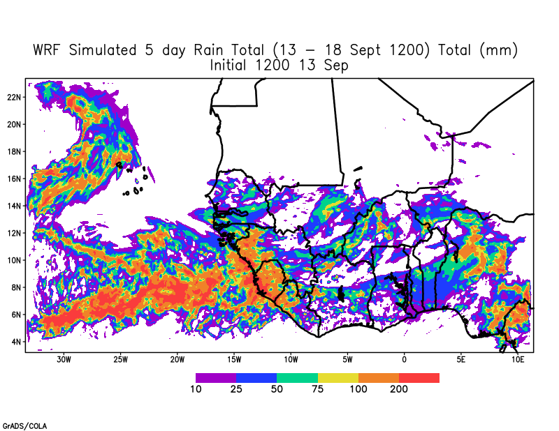
Consequently, forecasted rainfall across the Sahel is expected to be less during the week and also shifted to the south.
5 day total rainfall forecast for 13-18 September 2020
Inland Disturbance will move to the coast by week’s End.
The WRF forecast shows that a disturbance will reach the coast next Sunday. Further, the WRF forecast at 850 hPa indicates that the disturbance has a northern and southern component. In these situations, the AEW is in phase and could emerge as two different disturbances or merge into one storm. One worrying trend is that global models are suggesting that the main disturbance over Mauritania will have a more southerly latitude potentially impacting countries to the south.
850 hPa Vorticity showing a disturbance over Mauritania at the end of the forecast.
We will have to watch the forecast more carefully starting tomorrow. Meanwhile, keep those along the Gulf Coast in positive energy and thoughts as they prepare for Hurricane Sally and Bermuda after they experienced Hurricane Paulette.
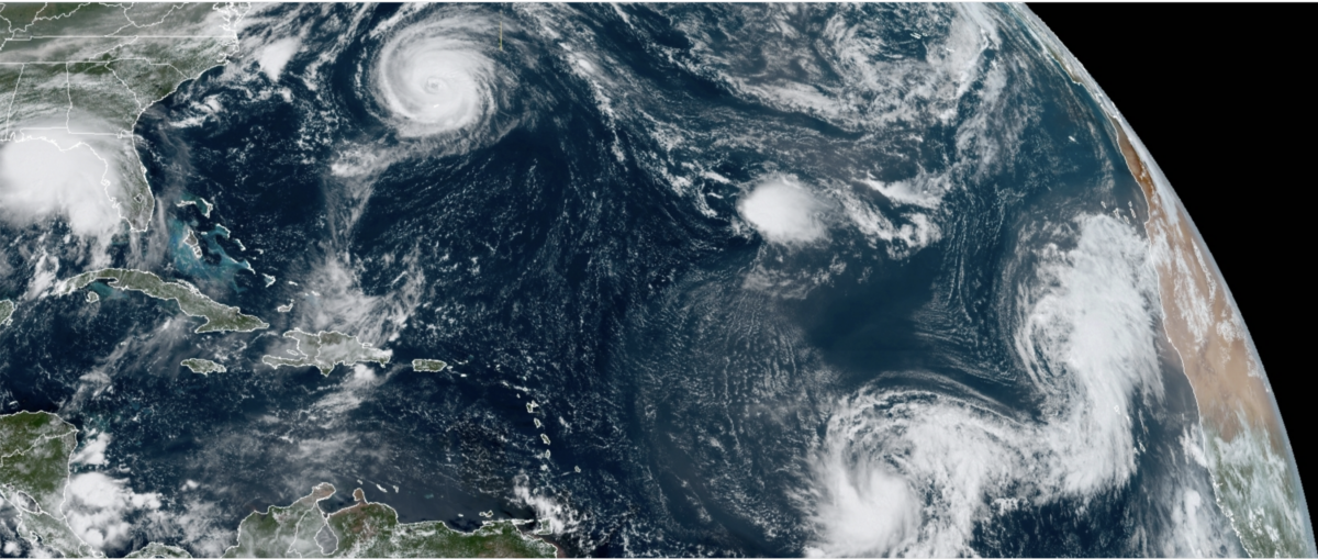
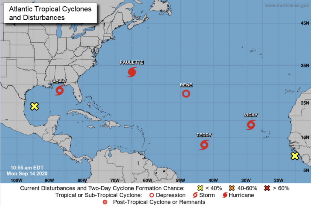
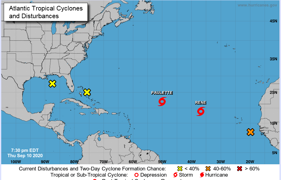
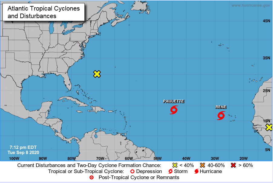
Today, there were five tropical systems across the Atlantic, with a 6th emerging off the coast of Africa.
National Hurricane Center tropical outlook as of 11 AM, Monday September 14.
I thought 2005 was bad, but I have never witnessed anything like this in all of the years that I have followed tropical systems. We still have another 77 daysleft in the season before it officially ends on November 30. We are on the V named storm in mid-September (incredible)! I feel that every African easterly wave that has emerged from Africa has formed a tropical cyclone. It seems like a scary movie from the middle 21st century when the planet is more than 2 C warmer than the pre-industrial period, but it is now.
Climate Change is REALand affecting Natural Hazards
I don’t know how long we can delude ourselves about what has happened over the last 5 years or more and what is happening this year. The events are causing more flooding, intensifying faster than weather forecast predict while coastal areas are increasing in population. Something is going to give and it’s not going to be these natural hazards. Hurricanes Irma, Michael, Florence, Laura, Harvey, Dorian, Paulette, Sally, Maria, Michael, and lesser storms are doing their damage in real-time.
What is strange about all of this is people’s response. They say we are going to rebuild because that is what we always do. But isn’t that a form of insanity when the systems are getting stronger and doing more damage? What about the people who can’t rebuild? What about the people that don’t recover, can’t afford the price of flood insurance, or get evicted because they are renters? A time is coming, when even those who feel buffered will lose everything and will just give up because they can’t….. any longer.
Overall I feel pessimistic about addressing climate change based on scientific evidence. Why?
Because people are disconnected from their contributions to climate change;
For many companies the bottom line is profit and they have a strong lobbying platform;
Climate change may manifest initially with a short burst (a massive wildfire or hurricane season) but the real change continues to creep on us in an invisible way that the majority of the world cannot envision (polar regions – melting sea ice and ice-sheets, acidification, rising CO2, N2O, and CH4 levels, loss of biodiversity on land and in the oceans;
Given the lack of will by countries and individuals to face a short term global pandemic (COVID-19), where the evidence from epidemiologist is clear and the numbers of individuals impacted are right in front of us (29 million cases, 930,000 deaths in the last year) — How can we face climate change?
If you have been or will be in the path of these storms (Cape Verde, Bermuda, Gulf Coast), I hope that you endured the event, are preparing or evacuating if necessary for an upcoming event, stay safe and healthy.
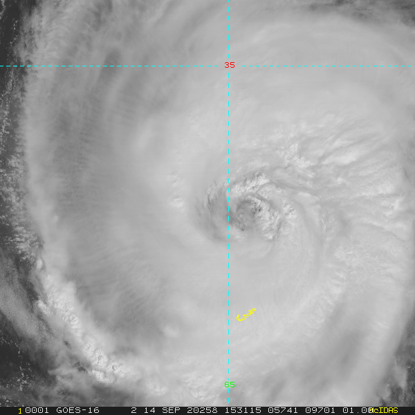
Hurricane Paulette passing North of the Bermuda this afternoon (Sep 14, 2020)
For the second weekend, heavy rainfall is impacting land areas in the Eastern Atlantic. Last week it was Senegal and now it is Cabo Verde. The rain came in late last night as a disturbed area associated with two tropical disturbances developed deep convection and quickly ran over Santiago and its capital Praia. A video from Facebook shows the rushing waters in the capital.
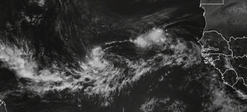
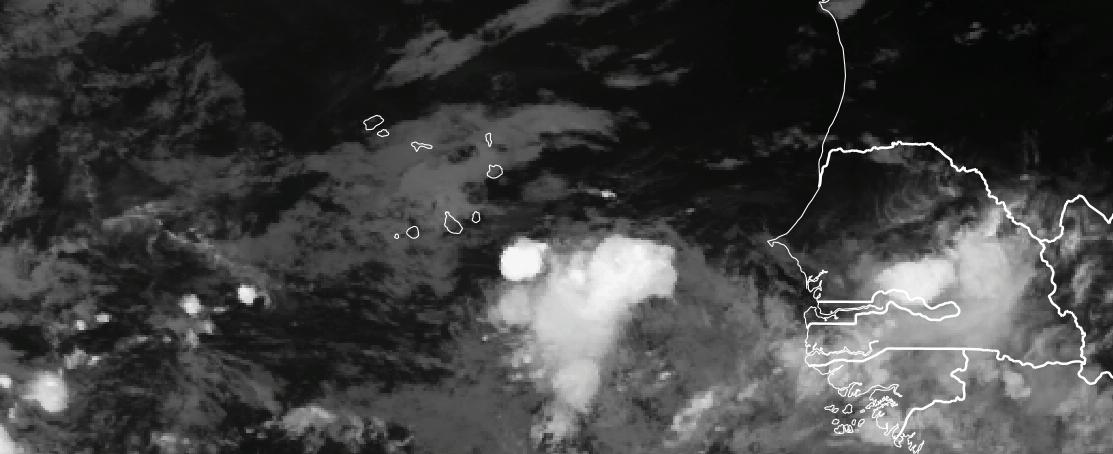
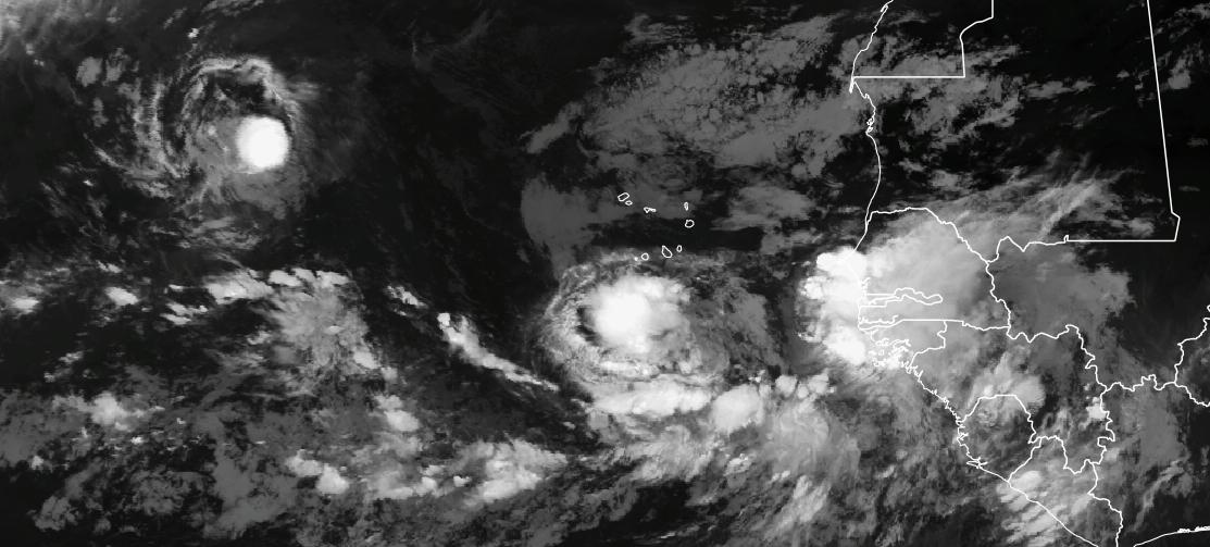
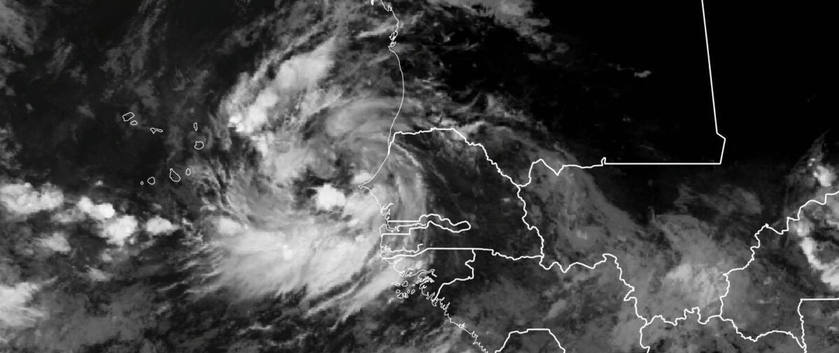
Video from Praia this morning Saturday Sept 12.Satellite imaging showing disturbance over Cabo Verde and its linkage to a second disturbed area to the West.
Global models have some issues with this system, because of the interaction with the storm further to the west. This connection means that until these two systems stop interacting then more rain is likely to fall over Cabo Verde for the next 24 hours.
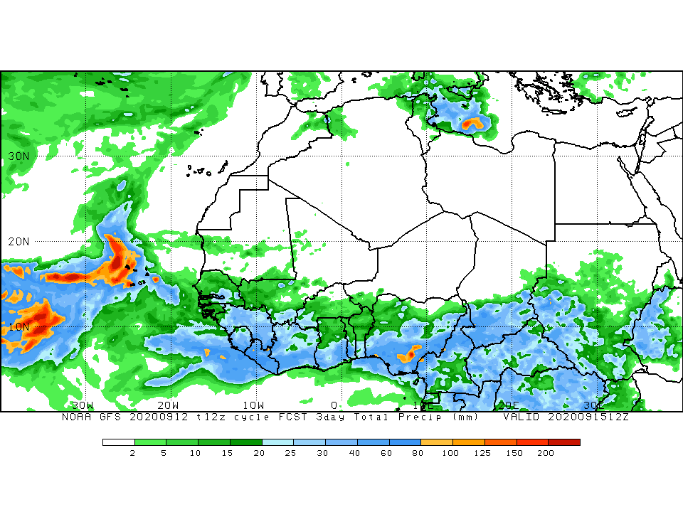
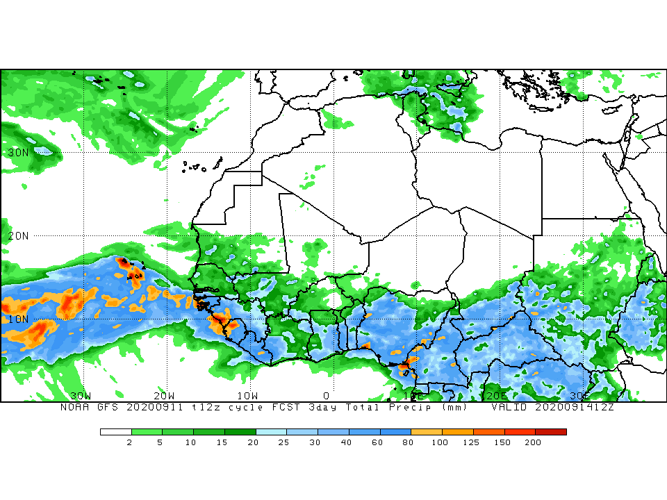
The 3 day precipitation for Cabo Verde from Saturday 1200 UTC – Tuesday 1200 UTC
The GFS shows heavy rainfall over the western part of Cabo Verde but there are real uncertainties at present about how much will fall. Rainfall amounts of 2-8 inches are still likely.
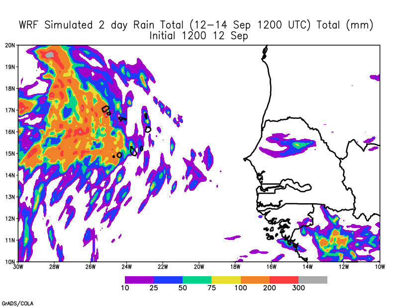
48 hour rain totals from WRF 1200 UTC initialized
The WRF model also shows heavy rainfall over the Western portion of the island of 4-8 (Santo Antao). So when does all of this happen or did it happen already?
Round 2 (Tonight and tomorrow)
Because of the connection between the two tropical systems, Cabo Verde is likely to have more rain tonight and tomorrow, even though the rain has stopped in many areas. Why??
The main disturbance is still passing across the countrys and this will be a slow process through Monday. Until the disturbance noted at 850 hPa (5000 feet completely leaves the area, rain will be possible.
WRF 850 hPa Relative vorticity based on 1200 UTC Sept 12 forecast
2. Moisture
The system in the South is drawing up moisture into Cabo Verde and will likely bring more rain beginning later tonight through Monday, with Santo Antao receiving the most rain and for the longest. The humid air at 5000 feet can be visually seen in the WRF forecast. WRF is forecasting rain of varying intensity is forecast to pass across the country tonight and tomorrow morning in parts of the country and through tomorrow night in Sao Vicente and Santo Antao as a result. Based on the latest satellite images maybe in the next few hours rain will return.
850 hPa Relative humidity based on 1200 UTC forecast. WRF forecasted radar reflectivity based on 1200 UTC Sept 12 forecast.
3. Low pressure and Winds.
This system has the potential to develop into a tropical cyclone after it passes Cabo Verde in the next few days. It is still possible that the Western parts of the country could see strong winds late Sunday and early Monday. I can’t say with 100 % confidence because there is so much variation in the models and we need to watch the disturbance as it passes Cabo Verde with care and identify any large burst of convection (thunderstorms) which could suggest strengthening.
WRF Forecasted surface winds based on September, 12 1200 UTC forecasts WRF Sea Level pressure and wind field based on Sept 12 1200 UTC forecast
Key Takeaways
The situation is fluid and heavy rain with Flash Flooding over Cabo Verde may occur at any point during the next 24 hours over most of the country. Rain should return to areas in the South over the next few hours. Be prepared to move to safety if necessary.
The Western Islands are expected to receive large amounts of rain through Sunday Night/late Monday. Elevated regions will have enhanced rain. Please prepare. Strong winds from the South may also occur from the South.
While a tropical depression is not likely until the system passes Cabo Verde late Sunday or Monday, it cannot be ruled out.
If you live in an area where water can rush against your house, please pay attention because the foundation can be destroyed.
Don’t drive across moving water. The force of moving water can easily carry your car away along with any persons inside.
Be SAFE!!
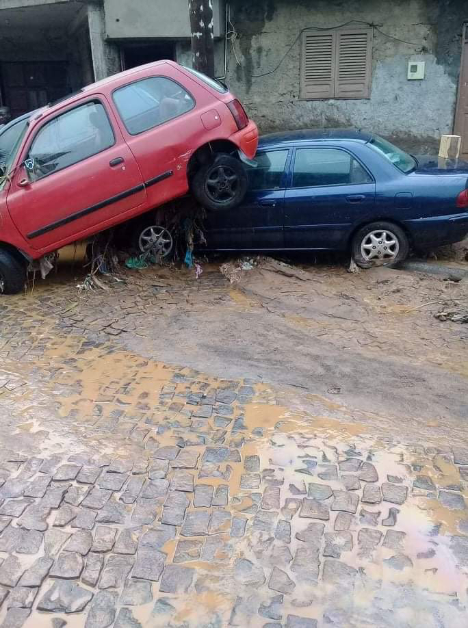
Images of destruction in Praia from running water posted in Facebook this morning.
Today, I have been waiting for insights from the model forecast in determining where an area of spin and area of persistent thunderstorms would form off the coast of West Africa. This area would represent a possible threat to Senegal or Cabo Verde depending where it happened. Tonight that area may have appeared to the southeast of Cabo Verde. The weekend forecast has been very complicated because yesterday’s forecast suggested that an area of low pressure would form to the east of Cabo Verde and today’s forecast to the west. The global models were suggesting a varied solution, but one strong possibility of heavy rainfall over Cabo Verde this weekend seemed likely. Let’s break down what we know..
The coastal disturbance
WRF Sea Level Pressure based on September 1200 UTC
The disturbance has been difficult to determine because of its interaction with a larger disturbance that exited the coast on Thursday and is likely to become a tropical cyclone in the coming days. The models have suggested that the new disturbance would break away on its own with an area of low pressure developing in the Western part of Cabo Verde on Saturday before moving off to the northwest.
However, at 5000 feet above the ground, the 850 hPa relative vorticity distinctly shows that the disturbance would be south of Cabo Verde and pass to the west of the country.
850 relative vorticity based on WRF 1200 UTC forecast
The model forecast show potentially southerly strong winds (30-40 knots at the ground) over Cabo Verde as the disturbance moves by the country on Sunday September 13.
WRF surface wind speeds and streamlines in Knots
RAIN Amounts during the Weekend
This is another problematic area. The Global model (GFS) suggest very heavy rain over the next 72 hours with the disturbance moving very slowly across Cabo Verde. These values exceed 100 mm (4 inches of rain) over the 72 hours and would likely produce flooding in Santo Antao
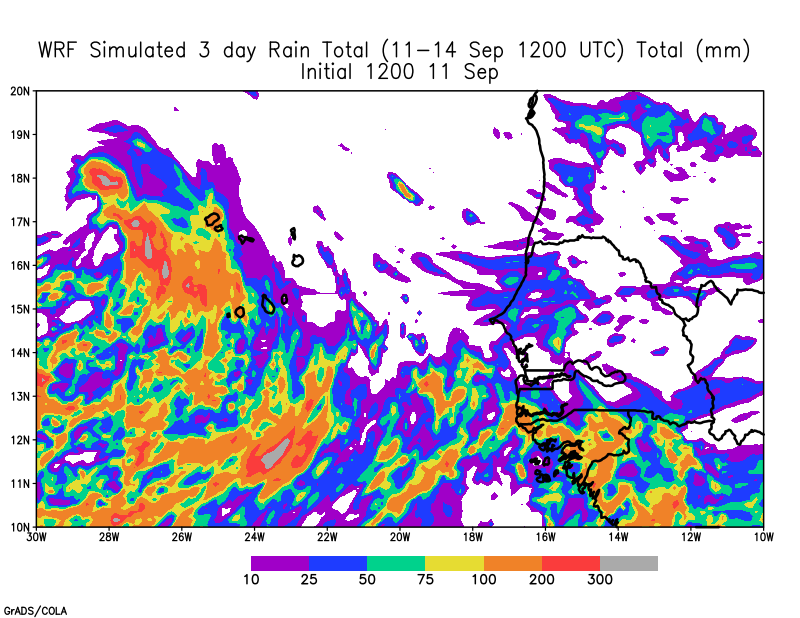
GFS 1200 UTC 72 hour precipitation for Sep 11-14 .WRF 72 hour accumulated rain from 11-14 September 2020
The WRF model on the other hand shows the heaviest rain to the west of Cabo Verde. This occurs because the area of low pressure moves off to the West of Cabo Verde. However, if the initial area of low pressure is to the east of Cabo Verde as tonight’s satellite images show, then all of the rainfall would be displaced further to the east and potentially impacting most of Cabo Verde. Gotta watch this one.
WRF simulated maximum Radar reflectivity (dbz ) and sea level pressure
Key Take away points
The threat of heavy rainfall in Senegal from the coastal disturbance has diminished. This will have the soils to dry out this weekend, but there may still be localized rains.
Deep convective clouds have been building over the last hour to the southeast of Cabo Verde. These are likely to produce rain over the country over the next 6-12 hours.
The threat of heavy rain and strong southerly winds will persist through the next 60-72 hours in Cabo Verde depending on if and where an area of low pressure develops.
Flash flooding could occur in elevated areas of Santiago and Santo Antao.
If you live in Cabo Verde, please follow the weather closely tomorrow through Monday and be prepared for heavy rain.
This morning the latest tropical disturbance was located off the coast of West Africa, with the global model forecast showing different solutions for the future of this tropical disturbance (Caribbean path, moving northwest to open waters). The system also has significant implications for Saturday through Monday’s weather in Senegal and Cabo Verde, because a second disturbance now over Guinea is going to move towards the Northwest tomorrow bringing additional rain over Senegal and then Cabo Verde. There are a couple of items to carefully examine in next 24-36 hours.
Recent Flooding in Senegal
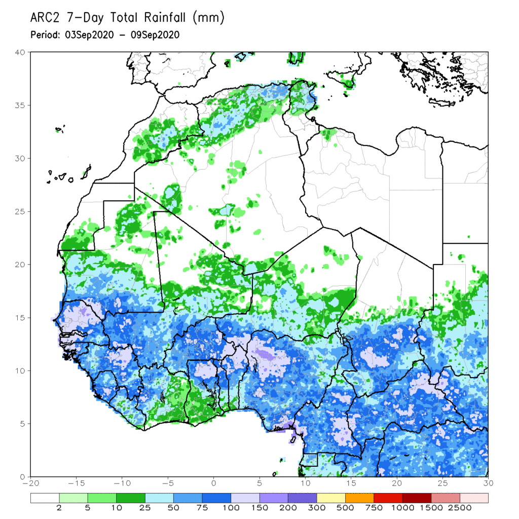
The past week has brought a tremendous amount of rain to Senegal because of last weekend’s storms. However, it has also rained over the past two days which doesn’t help. The ground is saturated and needs to dry out. Satellite-based rainfall shows the severity of the situation with very high rainfall amounts (4-6 inches of rain) across Senegal during the past week.
ARC estimated 7 day rainfall over West Africa, with heavy rainfall observed in Senegal and the Gambia
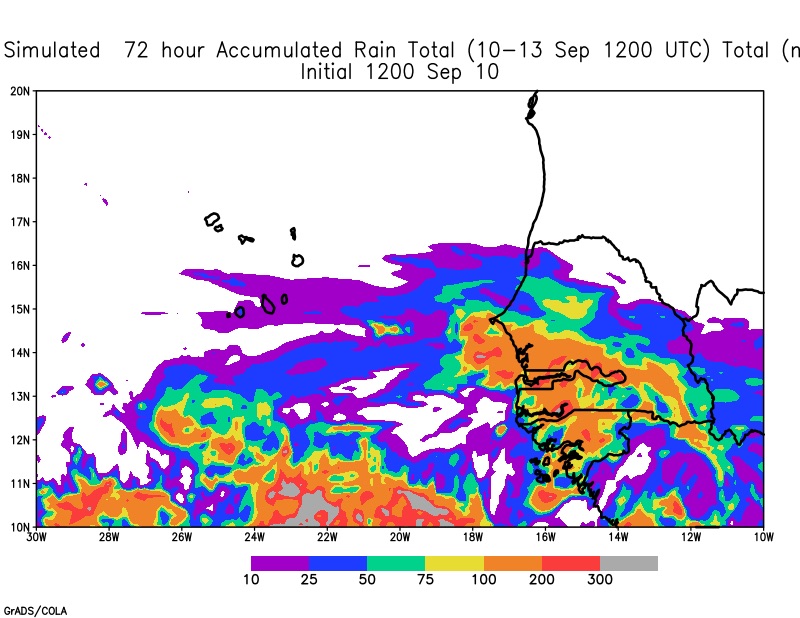
The WRF model is again forecasting relatively high rainfall amounts from Dakar and South(4-8 inches) because of a forecast squall line tomorrow and the disturbance that will move near Senegal in the next few days.
WRF forecasted 72-hour rain from Thursday through Sunday at 1200 UTC WRF forecasts radar reflectivity animation
How the Low-pressure area will impact the weekend weather
WRF animation of Sea Level Pressure based on September 10 1200 UTC
If you examine the animation above there is evidence of the main area of low pressure and at the end of the forecast the second area of low pressure. While they seem independent they aren’t. In fact, this is the complicated part of the forecasts.
This is evident through examination of the 700 hPa level vorticity where you can see that the main storm and the secondary storm are interacting with each other — not exactly binary interactions but something like that. At the end of the forecast, the secondary low breaks away from the main flow.
WRF 700 hPa Vorticity based on September 1200 UTC.
What all of this shop talk amounts to is uncertainty. For example, Tropical Storm Paulette which may eventually impact Bermuda form from the merging of two AEWs. I see three possibilities:
1.) the wave that emerged today, absorbs the AEW off the coast of Senegal this weekend with only rain in Cabo Verde but still some rain in Senegal.
2.) The wave that emerged today, captures the AEW for part of the period and the second wave eventually breaks away –as in the WRF forecast with some rain in Senegal and Cabo Verde
3.) The wave that emerged today remains as a separate entity from the second wave. That second wave could have a stronger circulation and being rain to coastal Senegal and heavier rain to Cabo Verde.
Not easy to tell, but hopefully tomorrow we will have more insight into this situation.
Key Takeaway
Senegal remains extremely vulnerable to additional flooding because of smaller scaled weather events and the potential for more rain tomorrow through Saturday.
The wave that emerged today may speed across the Atlantic towards the Caribbean, stay of the ocean, or hang out for a lower period in the Eastern Atlantic.
The Western and Central Atlantic along with the Gulf of Mexico also have tropical systems and potential disturbances. Stay alert and check in on the National Hurricane Center’s webpage
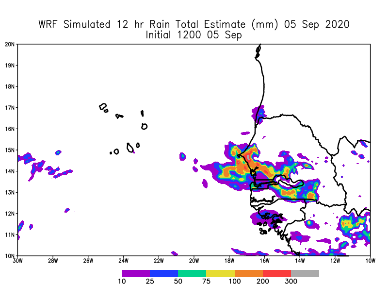
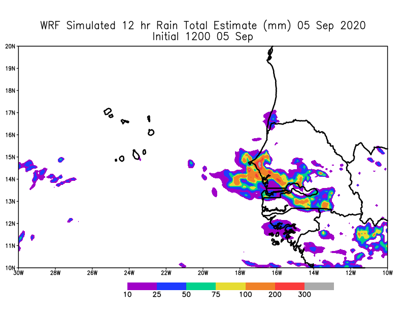
On Tuesday afternoon, Senegal and Cabo Verde were finally clear of the bad weather from TS Rene. Flooding was the main impact across both countries from TS Rene. While the models had been suggesting some development, what manifested was not expected entirely. WRF had been suggesting the heaviest rains in Western Senegal. But the large vortex that emerged was shocking.
WRF forecasted 12 hour Rainfall for Saturday September 5th, based on Sept 5 1200 UTC forecast.
Satellite images suggested very heavy rain and the irain product suggested that rain was heavy and the WRF forecast model was suggesting up 12 inches of rain in some places. Below are videos from Senegal including Dakar, Mbour, Thies and Diamdiadio (western Senegal) that were sent to me from colleagues by whatsapp and taken by video from people in those regions.
Video from roads — in Dakar on Sunday, Sept 6Flooding in a house in SenegalFlooding in a house in SenegalFlash Flooding in countryside of Western Senegal (sad)Flooding Sat night/Sunday morning in Dakar (Ngor neighborhood)flooded roads in Senegal
You get the point, that the situation was serious and potentially life-threatening for people and animals. I am going to comb through the surface observations this morning to get a sense of what fell on the ground.
Cabo Verde
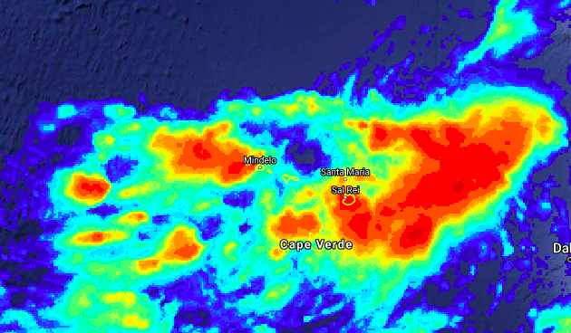
Tropical Depression 18 and then Tropical Storm Rene passed directly through the center of Cabo Verde. However, the reports are that it escaped heavy winds but there were reports of flooding in Santo Antao the more northwestern island which is very elevated. Satellite rainfall estimates suggest that Boa Vista, Sao Vicente and Santo Antao all received the highest rainfall. Of course, this all needs to be verified by ground measurements.
Irain product showing the highest rainfall for Sept 6-7 across Cabo Verde.
While, we can attribute this type of flooding to climate change, because of its association with a tropical disturbance, the atmosphere can hold more water vapor on a warmer planet. This will eventually manifest itself in heavier rainfall. Coastal West Africa and Cabo Verde are vulnerable now and definitely in the future unless CO2, Methane and other greenhouse gases are reduced. Because of these locations are situated near the Atlantic Ocean, disturbances have a moisture source to tap and as stated earlier the atmosphere can hold more water in a warmer world. There is evidence in the scientific literature that this is what is happening in West Africa, with heavier rainfall events over the last 2 decades. Future modeling studies by my colleague Dr. Bamba Sylla show that heavier rainfall events will manifest later this century with higher greenhouse gases.
The question that I have always struggled with is when does this happen?, is it gradual or is there a critical value with a tipping point?, after which, we never go back to earlier conditions. All of this feels like climate justice issue for the people in Africa who in general have historically contributed very little to the global burden of greenhouse gases. However, Africa’s its population increases and the use of fossil fuels increase it will contribute, which is why we need a different trajectory for the continent –> Solar energy, electric and hybrid cars and low-emission factories. The technology exists but is not readily made available to the continent and when it is, it is very expensive. Africa please unleash your innovative genius, because it is needed now!
While I was focused primarily on yesterday’s storm, the 1200 UTC forecast also showed that two potential storms would emerge this week.
Potential TC #1
The first is a wave that could move quickly across the Atlantic and impact the Caribbean next week. The global models have all picked up on this feature and the hurricane center gives is an 80% chance of TC formation over next 5 days.
NHC Tropical Weather Outlook for Tuesday September 8 850 hPa Vorticity based on September 7 (yesterday) 1200 UTC forecast.
The WRF model shows the system off the coast of West Africa Thursday at 0000 UTC. The sea level press is expected to decrease over time as the storm organizes itself on September 12. It is a fast mover that is for sure. We will follow it with tomorrow’s forecast.
WRF Sea Level pressure forecast based on Sept 7 1200 UTC
Potential TC #2
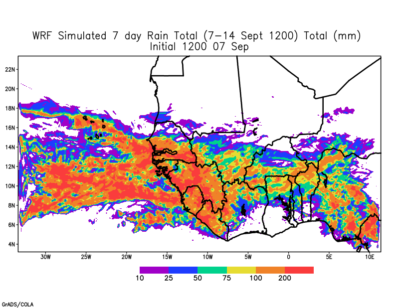
The second system is less discernable in the early part of the week and will initiate from a low amplitude AEW in low latitudes. It will gain latitude and finally is off the coast of Senegal on September 12 before passing onward into Cabo Verde. This is not that different from the system that produced Tropical Storm Rene and needs close watching. The potential to bring additional heavy rain to Senegal has me worried about the upcoming weekend.
WRF 7 day rain forecasts
Once again, the African Easterly Jet is expected to provide energy and spin to the system that may form off the coast on Friday. Let’s see what tomorrow’s forecasts say.
WRF forecast 700 AEJ based on 07 September 1200 UTC forecast
The potential for active and potentially dangerous disturbance for coastal West Africa and Cabo Verde remains high. Stay vigilant!!
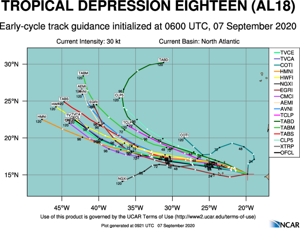
In the next few hours, Cabo Verde will begin to experience the effects of Tropical Depression 18. This is earlier than expected based on earlier forecasts. The Islands of Boa Vista and Sal should expect heavy rains and winds that may reach tropical storm force values. It is likely that the entire country will see heavy rain from this storm and that the northern islands could be impacted the worst at this time.
0600 UTC Early Track Guidance
The Early Track guidance suggests that the center of the storm will come closest to Boa Vista this afternoon and then tonight will move very close to Sao Nicolau, Sao Vicente, and Santo Antao. TD-18 will continue to strengthen as it cuts through the country and is likely to be a tropical storm when it reaches Boa Vista, Sal, Sao Nicolau, Sao Vicente and Santo Antao.
WRF 0000 SEPT 7 OutputAnalyses
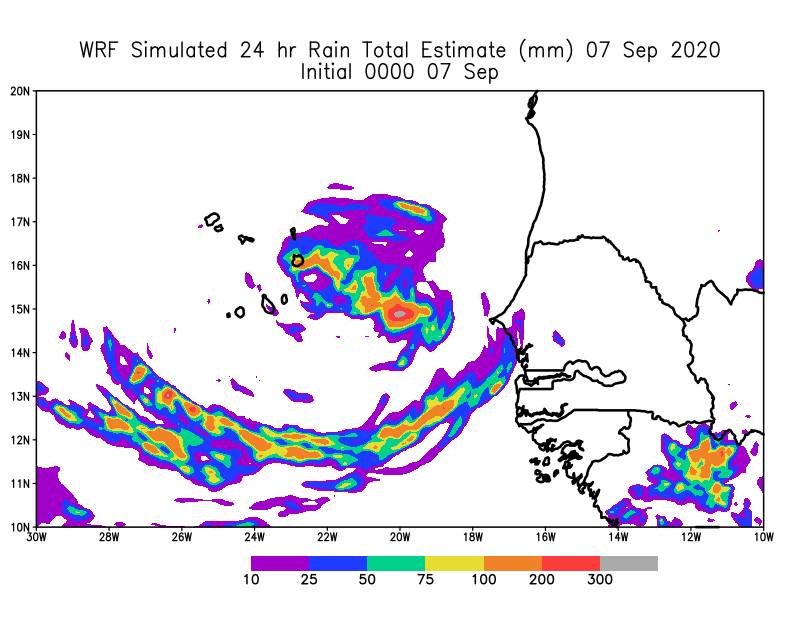
The WRF simulation from last night provides some insight of what is possible over the next 18 hours
Initial Rains
The model suggest that the first rains will reach Sal and Boa Vista around 2000 UTC tonight. Satellite observations show that the first bands may arrive in the next few hours. I expect that when the main center arrives that the rain will be pretty heavy and extend southward to Santiago.
WRF Sea Level and simulated Maximum Reflectivity based on 0000 UTC forecast
Sea Level Pressure
WRF Sea Level Pressure forecasts based on 0000 UTC initialization
Based on the WRF forecast, the low will pass close to Boa Vista and Sal with tropical storm winds likely based on the latest NHC projection. During the night the low may pass over Sao Nicolau and then Sao Vicente and San Antao before continuing out to sea tomorrow afternoon. Because there are some high mountains, winds speeds and rains in these areas are likely to be enhanced.
Surface Wind Speeds.
WRF Surface winds speed based on 0000 UTC WRF run
Surface Winds speeds are likely to increase during the day as the storm deepens. Tropical Storm force winds can be expected over most of the Northern Islands, however these winds could be reached when rain bands pass by any part of the country.
WRF Rainfall Totals
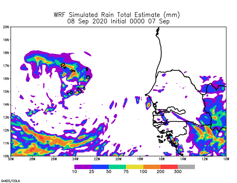
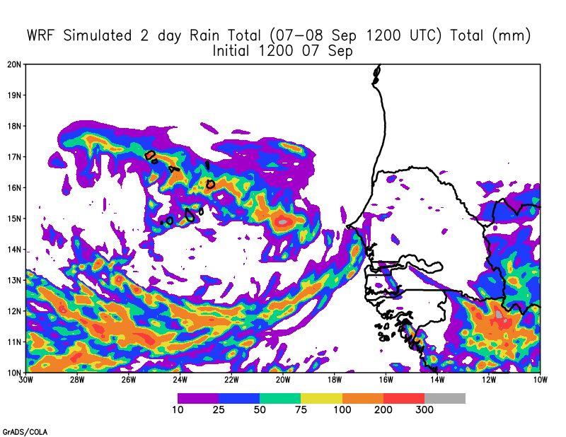
Rainfall will be heaviest over the Eastern part of Cabo Verde tonight and then shift to Western Cabo Verde overnight. The 48 hour totals could reach 100-200 mm and could be higher in elevated regions. The rain will be intense when it does occur.
WRF rainfall totals for Monday September 7WRF Rainfall Totals for Tuesday 8 September WRF 48 Hour rainfall based on 0000 UTC September 7
Key Takeaways
Make Final preparation for the storm now!! Charge your phones, fill your cars with gas and finish food shopping now. Touch based with loved ones before nightfall to make sure they are in good shape. Expect first rains in Sal, Boa Vista next few hours and poor conditions in about 5 hours.
Heavy rains could produce flash flooding, so be ready to move quickly if required to safety. Mountainous regions of Santiago, San Nicolau, Sao Vicente and Santo Antao are vulnerable to flash flooding tonight and tomorrow morning.
If you live near coastal zones, you will likely get some coastal flooding even for Islands to the south as a south fetch may produce heavy rains.
Some storm surge is expected Sao Nicolau, Sao Vicente and Santo Antao, if the storm passes the the south of these islands and even in the eastern parts of the islands based on the wind direction.
Please tune in to your local station to determine what is being done to protect people on your island and also know if there are local shelters.
Please pay attention to fallen trees and down electric power lines and wait until daylight tomorrow to assess the situation. Do not go out into the storm please.
Keep a cool head and prepare!!
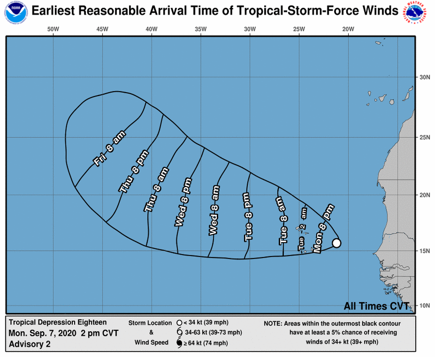
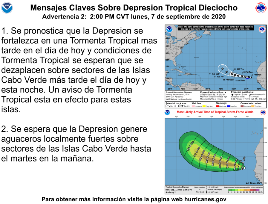
Below are images from National Hurricane Center (1500 UTC)
NHC time of arrival for TD-18Key Message in Spanish… Close to Portuguese but not exactly…..
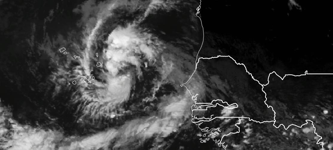
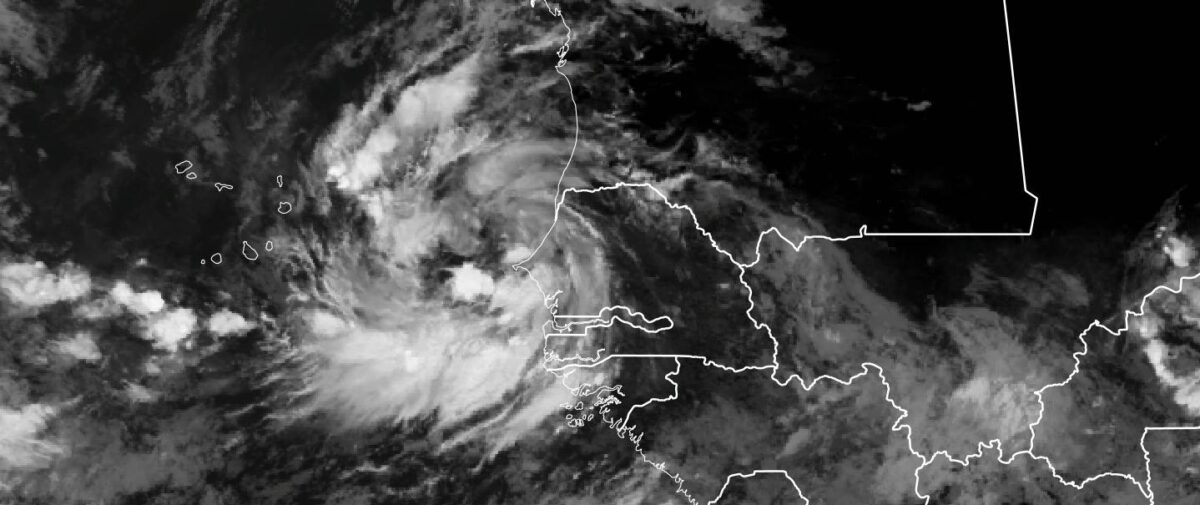
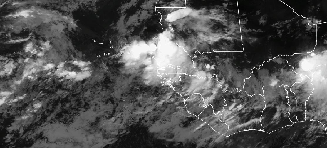
When I woke up this morning, I did not expect to see an organized tropical disturbance, with clear cyclonic flow and banding. The last time that I saw this type of organization for such a large system was 2006, when TD-8 formed off the coast of Senegal during the NASA African Monsoon Multidisciplinary Analysis (NAMMA) campaign. However, that system was further south and many hundreds of miles more out to sea.
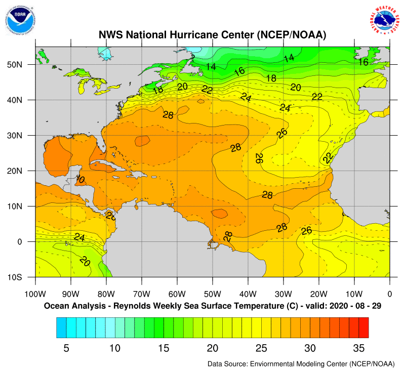
The global models are still not developing this system into a tropical cyclone near the coast, but I would say that the satellite observations should be enough to see the potential development. Ocean temperatures are above the threshold needed for tropical development (26 C) to occur and warm temperatures extend westward across the Atlantic to the United States.
Sea Surface Temperatures for the last week.
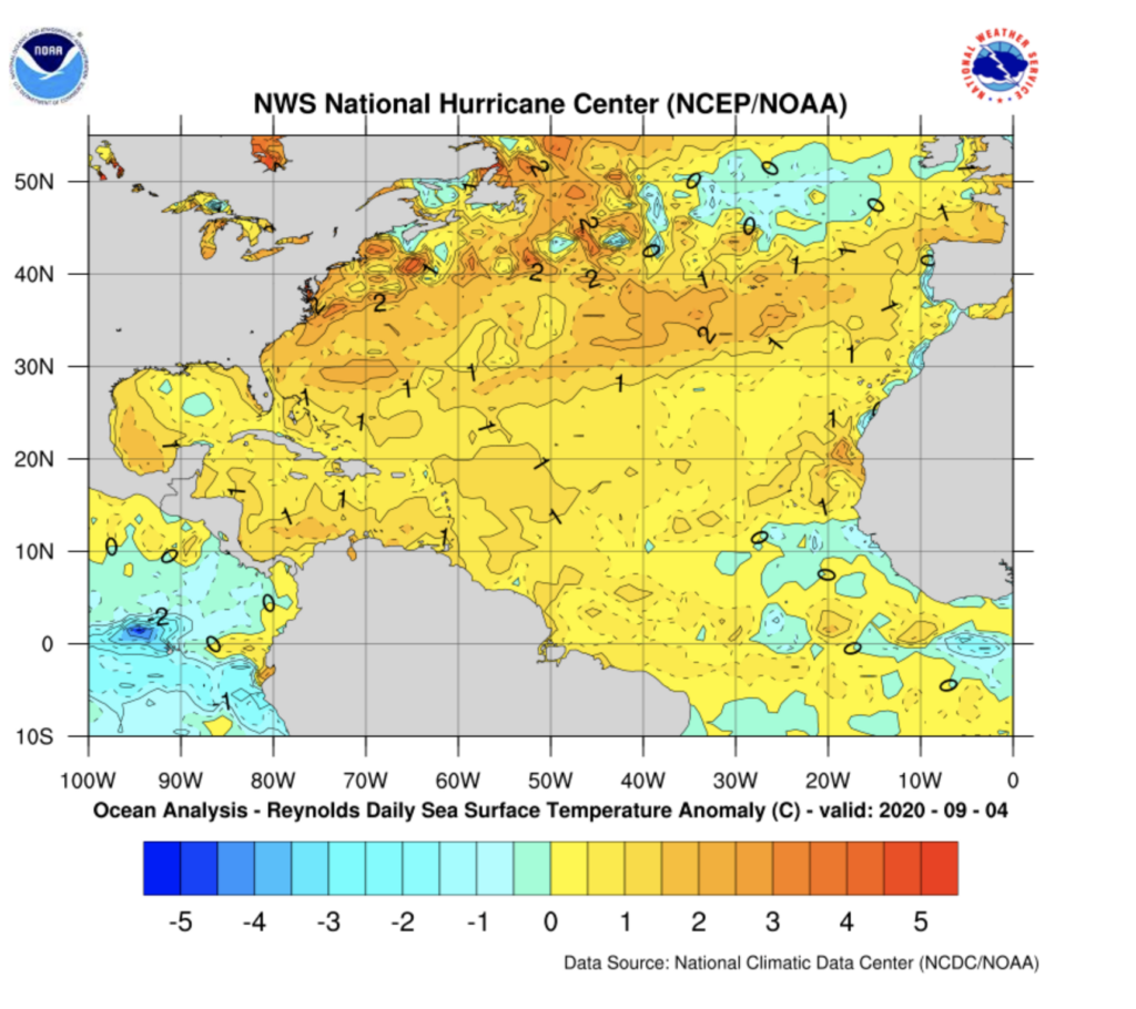
The latest Sea Surface Temperature anomalies show that waters off the coast of Senegal are 1 Degree C- 1.8 F) above normal which may provide additional energy for the storm to develop.
NOAA Sea Surface Temperature anomalies as of September 4
Key Takeaways
The tropical disturbance is organizing and is larger than suggested in model simulations. Over the next few hours, I feel that this will be an Invest and additional high-resolution hurricane models will focus on the system. For real-time images you can go to CIMSS http://tropic.ssec.wisc.edu/# as they are now following the system, just click on the invest (I).
Senegal –
expect additional bands of heavy rain, today until the system moves away. Please careful for flash flooding and standing water on the roads.
A strong fetch from the south will occur over the next day and coastal flooding may become a real-possibility to many fishing communities and Dakar.
Pay attention to the national meteorological services, local TV, and Radio broadcast on weather conditions. If possible report your conditions via social media. Check-in with Raid on facebook at: La Météo Dakaroise de Riad
Cabo Verde– You should prepare for:
several days of rain and wind, with the possibility of tropical-storm-force winds on some of the islands.
The seas will be rough and coastal flooding is also possible. Fishermen should be careful.
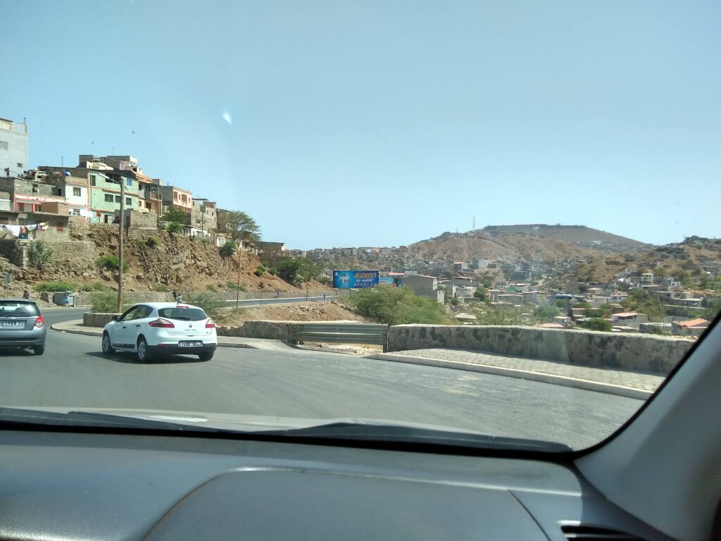
In areas that are flood-prone or have steep hills also prepare for possible flash flooding especially tomorrow and Tuesday. This includes the city of Praia where the houses tend to sit on steep hills.
Homes in Praia Cabo Verde
Until later… Stay safe and will update this evening……
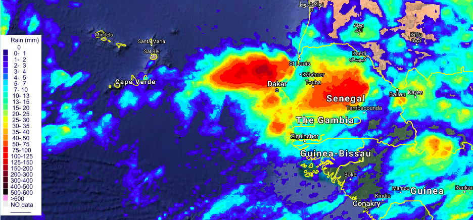
An infrared satellite view from EUMETSAT at 0200 UTC (10 PM) shows deep convection indicating that heavy rain is falling across Senegal, likely creating life-threatening flooding in some regions. Rainfall estimates from UIUC show that a 100 mm or (4 inches of rain) have fallen in some parts of Senegal.
CHRS Irain product September 5, 2020
The heavy rain is tied to a tropical disturbance that is expected to develop over the next few days and move across Cabo Verde.
Global Forecast models have had a time determining the strength of a possible disturbance, however they all agree that some type of disturbance is going to pass across Cabo Verde.
I have been using the Weather and Research Forecast model in research mode to determine the potential strength and path of the disturbance. Thus far, the model has been consistently developing a tropical storm that passes across Cabo Verde.
Sep 5 1200 UTC forecasts
Intensity and path of the forecasted storm
In the last model forecast from this afternoon, a tropical depression/storm develops but the path is further south and more likely to impact the island Santiago where the capital is located. The system continues to deepen as travels across Cabo Verde as it moves into Westward. For those of you who remember, Hurricane Florence which struck North Carolina took a similar path (not saying that is is likely as the storm has thousands of miles to travel to reach the US)
WRF forecasted Sea level pressure through September 11 at 1200 UTC
The forecast also suggests that much of Cabo Verde will receive winds that could be tropical depression to tropical storm force values especially on September 8. The wind field expands as it moves through Cabo Verde on September 8, with western islands likely to see the strongest winds as the storm deepens.
Heavy rain a major threat to Senegal and Cabo Verde.
Today’s 1200 UTC forecast shows that a large rain field will develop as the storm moves westward.
WRF Sept 5, 1200 UTC simulated maximum radar reflectivity
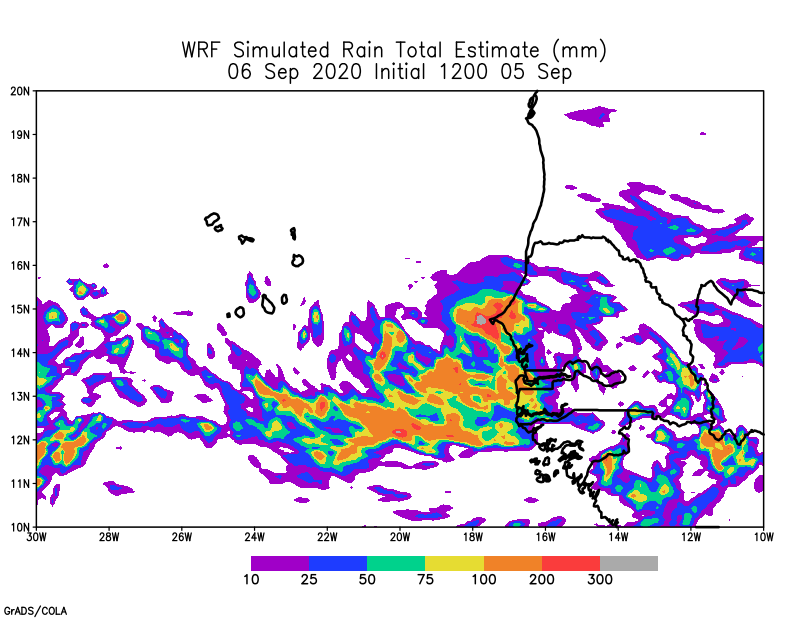
The heaviest rainfall would first impact Senegal on 5 and 6 September and then Cabo Verde on during the evening of 7 September. The predicted rain amounts would cause significant and widespread flooding if it occurred. The rainfall amounts were very high near Dakar on Saturday 05 September
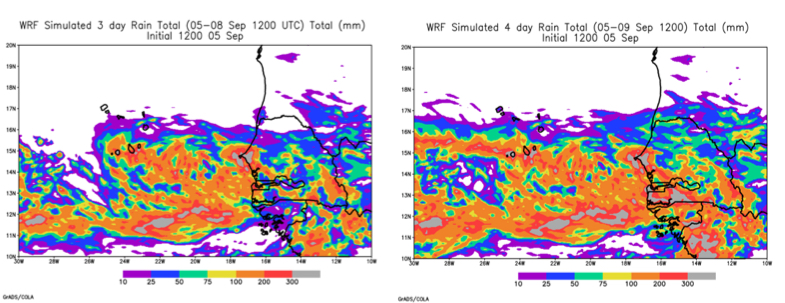
WRF Forecast September 5 total rainfall (1200 UTC – 2359 UTC) WRF Forecast Rainfall for September 5 WRF 72 and 96 hour Forecast of Rain amounts in mm
The forecasts suggest that heavy rain will persist in Western Senegal on Sunday September 6 and as the storm moves westward will also produce high rainfall over Cabo Verde. The amounts foreasted in the model are beyond 10 inches for 4 days across Senegal and southern portions of Cabo Verde
Key Take Way Messages
If you live in Senegal, please protect yourself from heavy flooding and seek shelter if your life is threatened. Please be careful driving and do not drive across flooded roads.
Heavy rain is possible in Senegal until the storm pulls away from the coast on Sunday.
While we do not know the degree of the potential storm and its impacts on Cabo Verde, all models indicate that some type of disturbance will make its way across the islands from late Monday through midnight Tuesday and potentially early Wednesday. Better to be prepared.
A developing system that strengthens will pose some level of threat for coastal zones in Cabo Verde but it is still to early to tell the path of the storm or the strength of the winds which might produce surge and strong beach erosion. Fishermen and women will need to pay close attention to the news and the flag systems at local ports.
Low lying and flood prone areas should be identified over the next 36 hours in Cabo Verde.
Stay tuned to your local stations as the forecasts should get better as we get closer to the event.
If a strong storm does come, make sure that you are prepared to deal with potential power outages.